Saguaro National Park is a United States National Park that is located near Tucson in the state of Arizona. There are two separate regions of the park: Saguaro East lies twenty miles east of Tucson, and Saguaro West is located fifteen miles west of the city center.
Understand
Saguaro National Park protects two separate areas of the Sonoran Desert near Tucson. While both Saguaro East and Saguaro West contain high densities of saguaro cacti, the park is also home for numerous other desert species.
History
Saguaro National Monument was initially created in 1933 by President Hoover, and became the 52nd national park in 1994. Initially Saguaro National Monument consisted only of what is today Saguaro East (the Rincon Mountain District), with 15,364 acres of Saguaro West (the Tucson Mountain District) being added in 1964 by President Kennedy, and an additional 21,000 acres added later.
Climate
High temperatures during the summer frequently rise above 105 F, and an average of less than twelve inches of rain falls in the park each year. Summer low temperatures average a still-balmy 75 F. During the winter, the high temperature averages a much cooler 65 F, with nighttime lows around 40 F.
Landscape
The park is located within the Sonoran Desert, a dry and hilly area that includes both the Tucson Mountains and the Rincon Mountains.
Flora and Fauna
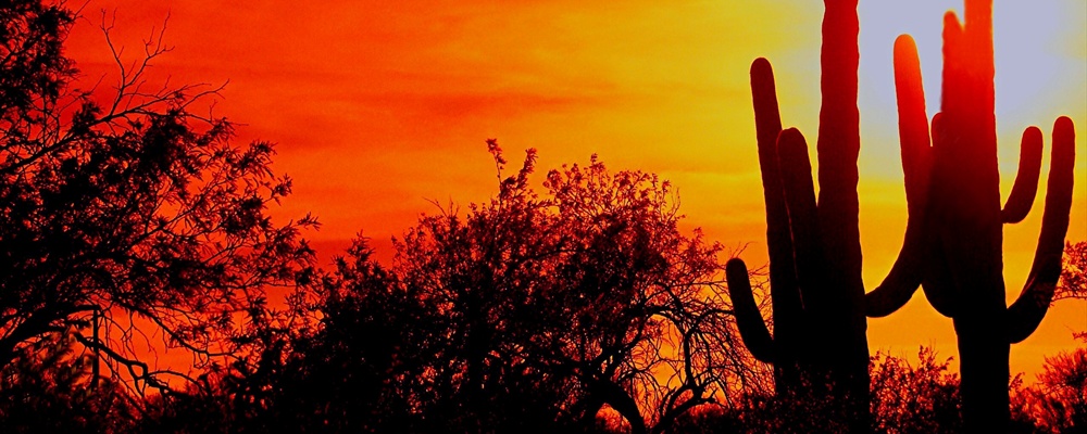
The park's namesake, the massive saguaro can live as long as 200 years, growing over fifty feet tall and weighing more than ten tons. The saguaro has become an icon of the desert, with its distinctive tall trunk and numerous curved arms that branch upward. The saguaro survives in the hot, dry desert through a series of adaptations, including a folded skin that can expand or contract depending on the amount of water collected. In addition, the lack of leaves and the plant's waxy skin reduces evaporation losses. Unlike most plants cacti perform photosynthesis in their trunk. The saguaro's root system usually lies within three inches of the ground surface and spreads out in a circle roughly as wide as the plant's height, allowing the cactus to collect any rainwater that may fall nearby.
Other species of cactus in the park include the wide barrel cactus, the spiny fishhook and cholla cacti, and the oddly-constructed prickly pear cactus. Various bushes, including creosote and mesquite, as well as numerous desert wildflowers, fill the desert with flowers after rains.
Most animals in the desert are difficult to spot due to their nocturnal habits or camouflage, but keen-eyed visitors might find quail, roadrunners, woodpeckers, flickers, wrens, owls, hawks, desert tortoise, gila monsters, javelinas (wild pigs), kangaroo rats, coyotes, foxes, and jackrabbits.
Getting there
By plane
Tucson International Airport (IATA : TUS) lies between the park's two districts.
By car
Saguaro East (Rincon Mountain District)
When traveling on I-10 west towards Tucson, take the Houghton Road exit (exit 275) north to Escalante Road, then turn right, heading east to Old Spanish Trail. Follow the signs to the park.
When arriving from the city of Tucson, follow Speedway Boulevard (exit 257 on I-10) east to Freeman Road then take Freeman Road to Old Spanish Trail. Look for signs to the park entrance.
Saguaro West (Tucson Mountain District)
When traveling on I-10 east towards Tucson, take the Avra Valley Road exit (exit 242) to Sandario Road, then turn left and head south, following the signs to the park.
To get to Saguaro West from the city of Tucson, take Speedway Boulevard west. At the junction of Camino de Oeste, Speedway Boulevard becomes Gates Pass Road. Continue west on Gates Pass Road to Kinney Road. Take Kinney Road north, following signs to the park. Due to winding, narrow mountain grades, vehicles with trailers and RVs over 25 feet are not recommended through Gates Pass and should use the Ina Road exit (exit 248) on I-10, traveling west to Sandario Road, then turning left and heading south, following signs to the park.
Traveling around
By car
A private vehicle is by far the easiest way to get around in either district of the park. No public transportation serves the park.
By bike
In the winter months a bike is an option for exploring the roads and some of the trails within the park; however, during the summer the weather can make exploration by bike a rather unpleasant experience.
Cactus Forest Loop Drive. An eight mile paved road in East Saguaro that is used by cars, bikes and joggers. Numerous sharp turns and hills make this a challenging but scenic option.
Cactus Forest Trail. A 2.5 mile dirt trail that bisects the Cactus Forest Loop Drive in East Saguaro. This trail is also used by hikers and equestrians, and bikers must yield to both.
By foot
There are over 150 miles of hiking trails in the park, ranging in difficulty from paved nature walks to difficult treks through the hills of the Sonoran Desert.
See
Rincon Mountain Visitor Center. Open 9:00 AM to 5:00 PM daily, closed on Christmas Day. The visitor center provides park information, a fifteen minute orientation film, and exhibits on the natural and cultural history of the Sonoran Desert.
Tucson Mountain Visitor Center. Open 9:00 AM to 5:00 PM daily, closed on Christmas Day. Like the Rincon Mountain Visitor Center, this visitor center provides park information, a fifteen minute orientation film, and exhibits on the natural and cultural history of the Sonoran Desert.
Things to do
Scenic Drives. In West Saguaro, the six-mile Bajada Loop Drive (unpaved) leads through a large saguaro forest. In East Saguaro, the eight-mile Cactus Forest Drive (paved) also passes through a dense saguaro forest.
Hiking. There are over 150 miles of trails in the park's two districts.
Hugh Norris Trail (West Saguaro). An eleven mile round-trip that leads to the summit of Wasson Peak, gaining over 2000 feet of elevation in the process. This trail passes through some beautiful desert landscape and provides excellent views.
Tanque Verde Ridge Trail (East Saguaro). This trail provides access to the backcountry areas of Saguaro East. It is a strenuous, multi-day trek that passes by the 7,049 foot Tanque Verde peak. Inquire at the visitor center for more information.
Photography. The park provides exceptional sunrise and sunset photography. Flowers and cacti bloom throughout the year, with the saguaros sprouting large white flowers during May and June.
Eat
There is no place within the park to purchase food, although there are numerous roadside picnic areas. An abundance of restaurants and grocery stores are located within a short drive from the park boundaries as well as in Tucson.
Drink
While not known for its bar scene or wild nightlife, the wily traveler may nevertheless be able to purchase bottled water at a visitor center. Budget travelers may be more interested in the free water dispensed from the fountains at either visitor center. Note that aside from the visitor centers, water is not generally available in the park. For anything stronger, a visit to the business establishments located outside of the park's boundaries will be required.
Sleep
Lodging
There are no hotels located within the park, but numerous lodging options are available nearby in Tucson.
Camping
There are no organized campgrounds within either section of the park, although backcountry camping is allowed in Saguaro East.
Backcountry
Backcountry camping is allowed only in the six backcountry campgrounds of Saguaro East. These campgrounds are accessible only by foot or by horse, and are a minimum of six miles from the nearest trailhead. These six campgrounds contain twenty-one sites, and facilities include pit toilets and fire circles, with water available seasonally at some sites. All backcountry camping requires a wilderness permit, which can be obtained for $6 from the Visitor Center.
Buy
Both visitor centers have bookstores which feature material of local interest.
Safety
The greatest danger in the park is the heat. Plan on drinking at least one gallon of water per day, and never hike without carrying water. When hiking, drink frequently even if you do not feel thirsty as the onset of thirst in the desert is often the first sign of dehydration. During storms flash floods can pose serious hazards, and it is advisable to stay out of washes and canyons.
Additional dangers exist from the flora and fauna within the park. Stepping on or touching a cactus spine can be an (obviously) painful experience; staying on the trails minimizes the chances of an unwanted cactus encounter. Rattlesnakes and gila monsters are both poisonous, but in general neither will bite unless surprised or threatened. Scorpion stings are painful but not fatal, and can be easily avoided by not reaching under rocks. Javelinas may be dangerous if cornered.
Fees/Permits
All private vehicles entering Saguaro East must pay a $10 entrance fee that is valid for seven days. Individuals on foot or bicycle must pay a $5 entrance fee, also valid for seven days. Those with a National Park Pass ($50, allows entrance to all national park areas for one year) do not need to pay the entrance fee. There are no fees for Saguaro West.
Tucson
Contact & location
Be the first one to add a review
The photos displayed on this page are the property of one of the following authors:
Saguaro National Park is a United States National Park that is located near Tucson in the state of Arizona. There are two separate regions of the park: Saguaro East lies twenty miles east of Tucson, and Saguaro West is located fifteen miles west of the city center.
Understand
Saguaro National Park protects two separate areas of the Sonoran Desert near Tucson. While both Saguaro East and Saguaro West contain high densities of saguaro cacti, the park is also home for numerous other desert species.
History
Saguaro National Monument was initially created in 1933 by President Hoover, and became the 52nd national park in 1994. Initially Saguaro National Monument consisted only of what is today Saguaro East (the Rincon Mountain District), with 15,364 acres of Saguaro West (the Tucson Mountain District) being added in 1964 by President Kennedy, and an additional 21,000 acres added later.
Climate
High temperatures during the summer frequently rise above 105 F, and an average of less than twelve inches of rain falls in the park each year. Summer low temperatures average a still-balmy 75 F. During the winter, the high temperature averages a much cooler 65 F, with nighttime lows around 40 F.
Landscape
The park is located within the Sonoran Desert, a dry and hilly area that includes both the Tucson Mountains and the Rincon Mountains.
Flora and Fauna
The park's namesake, the massive saguaro can live as long as 200 years, growing over fifty feet tall and weighing more than ten tons. The saguaro has become an icon of the desert, with its distinctive tall trunk and numerous curved arms that branch upward. The saguaro survives in the hot, dry desert through a series of adaptations, including a folded skin that can expand or contract depending on the amount of water collected. In addition, the lack of leaves and the plant's waxy skin reduces evaporation losses. Unlike most plants cacti perform photosynthesis in their trunk. The saguaro's root system usually lies within three inches of the ground surface and spreads out in a circle roughly as wide as the plant's height, allowing the cactus to collect any rainwater that may fall nearby.
Other species of cactus in the park include the wide barrel cactus, the spiny fishhook and cholla cacti, and the oddly-constructed prickly pear cactus. Various bushes, including creosote and mesquite, as well as numerous desert wildflowers, fill the desert with flowers after rains.
Most animals in the desert are difficult to spot due to their nocturnal habits or camouflage, but keen-eyed visitors might find quail, roadrunners, woodpeckers, flickers, wrens, owls, hawks, desert tortoise, gila monsters, javelinas (wild pigs), kangaroo rats, coyotes, foxes, and jackrabbits.
Getting there
By plane
Tucson International Airport (IATA : TUS) lies between the park's two districts.
By car
Saguaro East (Rincon Mountain District)
When traveling on I-10 west towards Tucson, take the Houghton Road exit (exit 275) north to Escalante Road, then turn right, heading east to Old Spanish Trail. Follow the signs to the park.
When arriving from the city of Tucson, follow Speedway Boulevard (exit 257 on I-10) east to Freeman Road then take Freeman Road to Old Spanish Trail. Look for signs to the park entrance.
Saguaro West (Tucson Mountain District)
When traveling on I-10 east towards Tucson, take the Avra Valley Road exit (exit 242) to Sandario Road, then turn left and head south, following the signs to the park.
To get to Saguaro West from the city of Tucson, take Speedway Boulevard west. At the junction of Camino de Oeste, Speedway Boulevard becomes Gates Pass Road. Continue west on Gates Pass Road to Kinney Road. Take Kinney Road north, following signs to the park. Due to winding, narrow mountain grades, vehicles with trailers and RVs over 25 feet are not recommended through Gates Pass and should use the Ina Road exit (exit 248) on I-10, traveling west to Sandario Road, then turning left and heading south, following signs to the park.
Traveling around
By car
A private vehicle is by far the easiest way to get around in either district of the park. No public transportation serves the park.
By bike
In the winter months a bike is an option for exploring the roads and some of the trails within the park; however, during the summer the weather can make exploration by bike a rather unpleasant experience.
Cactus Forest Loop Drive. An eight mile paved road in East Saguaro that is used by cars, bikes and joggers. Numerous sharp turns and hills make this a challenging but scenic option.
Cactus Forest Trail. A 2.5 mile dirt trail that bisects the Cactus Forest Loop Drive in East Saguaro. This trail is also used by hikers and equestrians, and bikers must yield to both.
By foot
There are over 150 miles of hiking trails in the park, ranging in difficulty from paved nature walks to difficult treks through the hills of the Sonoran Desert.
See
Rincon Mountain Visitor Center. Open 9:00 AM to 5:00 PM daily, closed on Christmas Day. The visitor center provides park information, a fifteen minute orientation film, and exhibits on the natural and cultural history of the Sonoran Desert.
Tucson Mountain Visitor Center. Open 9:00 AM to 5:00 PM daily, closed on Christmas Day. Like the Rincon Mountain Visitor Center, this visitor center provides park information, a fifteen minute orientation film, and exhibits on the natural and cultural history of the Sonoran Desert.
Things to do
Scenic Drives. In West Saguaro, the six-mile Bajada Loop Drive (unpaved) leads through a large saguaro forest. In East Saguaro, the eight-mile Cactus Forest Drive (paved) also passes through a dense saguaro forest.
Hiking. There are over 150 miles of trails in the park's two districts.
Hugh Norris Trail (West Saguaro). An eleven mile round-trip that leads to the summit of Wasson Peak, gaining over 2000 feet of elevation in the process. This trail passes through some beautiful desert landscape and provides excellent views.
Tanque Verde Ridge Trail (East Saguaro). This trail provides access to the backcountry areas of Saguaro East. It is a strenuous, multi-day trek that passes by the 7,049 foot Tanque Verde peak. Inquire at the visitor center for more information.
Photography. The park provides exceptional sunrise and sunset photography. Flowers and cacti bloom throughout the year, with the saguaros sprouting large white flowers during May and June.
Eat
There is no place within the park to purchase food, although there are numerous roadside picnic areas. An abundance of restaurants and grocery stores are located within a short drive from the park boundaries as well as in Tucson.
Drink
While not known for its bar scene or wild nightlife, the wily traveler may nevertheless be able to purchase bottled water at a visitor center. Budget travelers may be more interested in the free water dispensed from the fountains at either visitor center. Note that aside from the visitor centers, water is not generally available in the park. For anything stronger, a visit to the business establishments located outside of the park's boundaries will be required.
Sleep
Lodging
There are no hotels located within the park, but numerous lodging options are available nearby in Tucson.
Camping
There are no organized campgrounds within either section of the park, although backcountry camping is allowed in Saguaro East.
Backcountry
Backcountry camping is allowed only in the six backcountry campgrounds of Saguaro East. These campgrounds are accessible only by foot or by horse, and are a minimum of six miles from the nearest trailhead. These six campgrounds contain twenty-one sites, and facilities include pit toilets and fire circles, with water available seasonally at some sites. All backcountry camping requires a wilderness permit, which can be obtained for $6 from the Visitor Center.
Buy
Both visitor centers have bookstores which feature material of local interest.
Safety
The greatest danger in the park is the heat. Plan on drinking at least one gallon of water per day, and never hike without carrying water. When hiking, drink frequently even if you do not feel thirsty as the onset of thirst in the desert is often the first sign of dehydration. During storms flash floods can pose serious hazards, and it is advisable to stay out of washes and canyons.
Additional dangers exist from the flora and fauna within the park. Stepping on or touching a cactus spine can be an (obviously) painful experience; staying on the trails minimizes the chances of an unwanted cactus encounter. Rattlesnakes and gila monsters are both poisonous, but in general neither will bite unless surprised or threatened. Scorpion stings are painful but not fatal, and can be easily avoided by not reaching under rocks. Javelinas may be dangerous if cornered.
Fees/Permits
All private vehicles entering Saguaro East must pay a $10 entrance fee that is valid for seven days. Individuals on foot or bicycle must pay a $5 entrance fee, also valid for seven days. Those with a National Park Pass ($50, allows entrance to all national park areas for one year) do not need to pay the entrance fee. There are no fees for Saguaro West.
Contact & location
Be the first one to add a review
The photos displayed on this page are the property of one of the following authors:
P.J. Hamlin, Ken Bosma, Bri Lehman, rexboggs5, Ken Lund, kanu101, Dave Bezaire & Susi Havens-Bezaire, J
Some photos courtesy of: ,
,  . The photos provided by Flickr, Panoramio are under the copyright of their owners.
This travel guide also includes text from Wikitravel articles, all available at View full credits
AZTravel, Todd VerBeek, Nick Roux and Ryan Holliday, Inas and Jonboy
This travel guide also includes text from Wikipedia articles, all available at View full credits