Grand Staircase-Escalante National Monument is a unit of the United States national park system, in the state of Utah. If you like slickrock and slot canyons, this is the place to go. At 1.7 million acres, the monument encompasses a seemingly limitless number of destinations, although there are only a few roads that will take you to any of them. The Monument is situated between Bryce Canyon in the west, and Capital Reef and Glen Canyon National Recreation Area to the east.
Understand
History
First explored by Spanish priests seeking a route from Santa Fe to the California missions, this area of southern Utah remains one of the most sparsely populated regions in the West. For many years it received only token protection and was not part of the national park system, but threats to develop it for mining and commercial use led the Clinton administration to place it in National Monument status in 1996. This was done without consulting area residents and was not seen favorably in Republican-dominated Utah. It is managed by the Bureau of Land Management, rather than by the National Park Service.
Climate
Summers are hot, highs often reach well over 100 degrees. Summer nights are cool and pleasant. Expect afternoon thunderstorms from mid-June to late August. Winters can be cold and windy, with ample amounts of snow. The snow often melts within a few days, turning the dirt roads into mud pits.
Landscape
Deep sandstone canyons, surprisingly impressive waterfalls and acres of roadless wilderness. This is a desert lover's paradise.
Flora and fauna
Pinyon Juniper woodlands, desert grasslands and lush riparian areas.
Getting there
Fly into Las Vegas, Salt Lake City or Phoenix and rent a car. From Las Vegas take Interstate 15 North or from Salt Lake City take Interstate 15 South. In either case take State Route 14 east from Cedar City to State Route 12 or US 89, which will take you through the Monument. From Phoenix take Interstate 17 North to Flagstaff and then continue north on US 89, which take you into the Monument. Four wheel drive is highly recommended on any but the primary roads, although not strictly necessary.
Traveling around
There are only two paved roads that travel the width of the monument, Highway 89 to the south and Highway 12 to the north. There are several dirt roads that bisect the monument from north to south, such as Cottonwood Canyon Road and Skumtumpah Road, both which offer and treasure of slot canyons and hiking. Hole in the Rock Road offers access to the heart of Escalante and numerous trailheads, however it comes to a dead end at the north rim of the Colorado River. The dirt roads in the area can become impassable when wet due to the clay.
See
Cedar Mesa
Cottonwood Road
Escalante Canyons
Grosvenor Arch
Hells Backbone Road
Hole in the Rock Road
Johnson Canyon Road
Skutumpah Road
Staircase
Things to do
There are slot canyons for every level of canyoneering, from begineers to the very advanced. Don't get yourself into any situations you cannot get yourself out of. Know your own limitations. Do not hike in slot canyons if there is ANY chance that it could rain.
Escalante Area
Peek-a-boo and Spooky Canyons offer an easy introduction to canyoneering.
Calf Creek Falls is an easy 5.5 mile round trip hike to an impressive waterfall.
Hole in the Rock Road ends at an impressive trail that Mormon pioneers in the 1800s carved out of the cliffs in an effort to cross the Colorado River.
Skutumpah Road - From Glendale to Canonville
Lick Wash and Willis Creek offer an easy introduction to canyoneering. Lick Wash can get slippery if wet due to the clay. A small stream run through Willis Creek.
Bull Valley Gorge although a little more difficult slot canyon, most athletic people can handle this one. Do take a rope for emergencies. Ice cold water can accumulate in various spots in the canyon in the winter. Bull Valley Gorge can be connected to Willis Creek via Sheep Creek for a long day hike or an overnight backpack.
Cottonwood Road - Between Kanab and Page to Canonville
Hackberry Canyon is an easy stroll through a river.
Cottonwood Canyon is an easy slot canyon the entire family can enjoy.
Yellow Rock is an interesting hike to explore a yellow tinted mountain.
Wahweap - Big Water Area
Wahweap Hoodoos those magnificent white hoodoos seen in photographs everywhere.
There are plenty of other opportunies for hiking, backpacking, canyoneering, photography and just general sightseeing.
Guided Tours
Tag A Long Expeditions, 800-453-3292, 452 N. Main Street, Guided 4x4 tours into Grand Staircase/Escalante, Capitol Reef, San Rafael Swell and surrounding areas.
Eat
Mount Carmel Junction and Glendale. Glendale entrance to Skutumpah Road.
Kanab Near Cottonwood Road.
Big Water Wahweap Hoodoo area
Cannonville Skutumpah Road - Opposite end from Glendale.
Escalante Escalante Canyon area.
Drink
Mount Carmel Junction and Glendale. Glendale entrance to Skutumpah Road.
Kanab Near Cottonwood Road.
Big Water Wahweap Hoodoo area
Cannonville Skutumpah Road - Opposite end from Glendale.
Escalante Escalante Canyon area.
Sleep
Lodging
Mount Carmel Junction and Glendale. Glendale entrance to Skutumpah Road.
Kanab Near Cottonwood Road.
Big Water Wahweap Hoodoo area
Cannonville Skutumpah Road - Opposite end from Glendale.
Escalante Escalante Canyon area.
Buy
Johnson Canyon Road is 11 miles east of Kanab. It meets up with Skutumpah Road and continues to either Glendale or Canonville depending on the direction you choose. Kanab has a couple of grocery stores, motels, and restaurants.
Escalante and Boulder also have a couple of motels, outfitters, and small restaurants. Don't expect a gourmet meal, but don't think your options are limited to gorp and granola bars.
At the Glendale (East Zion) entrance to the Grand Staircase there is a Bed & Breakfast and one of the most unique bistros anywhere. Nearby is the small town of Orderville which has a grocery store and a motel. A couple more miles is Mount Carmel and Mount Carmel Junction. Glendale, Orderville, Mount Carmel and Mount Carmel Junction have several lodging and dining options between them.
Cottonwood Canyon Road is near Big Water, 32 miles east of Kanab. The dirt road is 46 miles long and ends at Cannonville. There are a few lodging and dining options at Cannonville and more if you head toward Bryce Canyon.
Safety
Do not hike in slot canyons when there is any threat of rain. Flash floods are common during the summer and are extremely dangerous.
Fees/Permits
Camping is free in unimproved areas.
Get out
You can get to the adjacent Glen Canyon National Recreation Area practically without noticing it, although this does require some seriously difficult driving (and possibly some overland desert hiking)
Zion National Park the most visited of all Utah's National Parks
Bryce Canyon National Park at the edge of the Grand Staircase but not within the boundaries of the monument. Bryce Canyon is one of those places that has jaw dropping beauty
The Grand Canyon (North Rim)
The bottom layer of the Grand Staircase and one of the seven wonders of the world. This rim is the more spectacular of the rims but its rustic setting keeps visitors to a minimum when compared to the commercial and populated South Rim. The Grand Canyon although part of the geological make-up is not within the boundaries of the monument.
Cedar Breaks National Monument
Often considered to be a top riser in the geography of the Grand Staircase although the boundaries are not within the monument. This is a spectacular monument that rivals Bryce Canyon National Park. It gets less visitors but its beauty certainly does not pale with the other parks.
Red Canyon Dixie National Forest
Coral Pink Sand Dunes State Park
Paria Canyon The Wave! A hot spot for photographers and hikers alike. Although Paria Canyon special permit area is on the edge of the monument it is not part of it.
Contact & location
Be the first one to add a review
The photos displayed on this page are the property of one of the following authors:
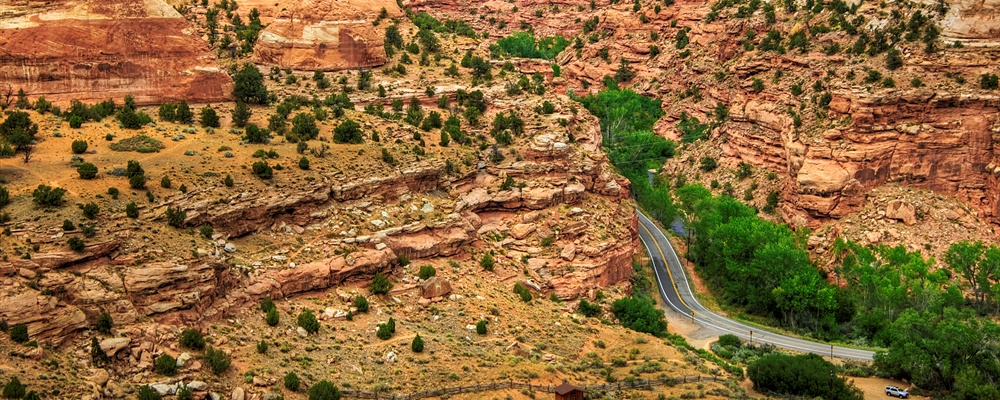
Grand Staircase-Escalante National Monument is a unit of the United States national park system, in the state of Utah. If you like slickrock and slot canyons, this is the place to go. At 1.7 million acres, the monument encompasses a seemingly limitless number of destinations, although there are only a few roads that will take you to any of them. The Monument is situated between Bryce Canyon in the west, and Capital Reef and Glen Canyon National Recreation Area to the east.
Understand
History
First explored by Spanish priests seeking a route from Santa Fe to the California missions, this area of southern Utah remains one of the most sparsely populated regions in the West. For many years it received only token protection and was not part of the national park system, but threats to develop it for mining and commercial use led the Clinton administration to place it in National Monument status in 1996. This was done without consulting area residents and was not seen favorably in Republican-dominated Utah. It is managed by the Bureau of Land Management, rather than by the National Park Service.
Climate
Summers are hot, highs often reach well over 100 degrees. Summer nights are cool and pleasant. Expect afternoon thunderstorms from mid-June to late August. Winters can be cold and windy, with ample amounts of snow. The snow often melts within a few days, turning the dirt roads into mud pits.
Landscape
Deep sandstone canyons, surprisingly impressive waterfalls and acres of roadless wilderness. This is a desert lover's paradise.
Flora and fauna
Pinyon Juniper woodlands, desert grasslands and lush riparian areas.
Getting there
Fly into Las Vegas, Salt Lake City or Phoenix and rent a car. From Las Vegas take Interstate 15 North or from Salt Lake City take Interstate 15 South. In either case take State Route 14 east from Cedar City to State Route 12 or US 89, which will take you through the Monument. From Phoenix take Interstate 17 North to Flagstaff and then continue north on US 89, which take you into the Monument. Four wheel drive is highly recommended on any but the primary roads, although not strictly necessary.
Traveling around
There are only two paved roads that travel the width of the monument, Highway 89 to the south and Highway 12 to the north. There are several dirt roads that bisect the monument from north to south, such as Cottonwood Canyon Road and Skumtumpah Road, both which offer and treasure of slot canyons and hiking. Hole in the Rock Road offers access to the heart of Escalante and numerous trailheads, however it comes to a dead end at the north rim of the Colorado River. The dirt roads in the area can become impassable when wet due to the clay.
See
Cedar Mesa
Cottonwood Road
Escalante Canyons
Grosvenor Arch
Hells Backbone Road
Hole in the Rock Road
Johnson Canyon Road
Skutumpah Road
Staircase
Things to do
There are slot canyons for every level of canyoneering, from begineers to the very advanced. Don't get yourself into any situations you cannot get yourself out of. Know your own limitations. Do not hike in slot canyons if there is ANY chance that it could rain.
Escalante Area
Peek-a-boo and Spooky Canyons offer an easy introduction to canyoneering.
Calf Creek Falls is an easy 5.5 mile round trip hike to an impressive waterfall.
Hole in the Rock Road ends at an impressive trail that Mormon pioneers in the 1800s carved out of the cliffs in an effort to cross the Colorado River.
Skutumpah Road - From Glendale to Canonville
Lick Wash and Willis Creek offer an easy introduction to canyoneering. Lick Wash can get slippery if wet due to the clay. A small stream run through Willis Creek.
Bull Valley Gorge although a little more difficult slot canyon, most athletic people can handle this one. Do take a rope for emergencies. Ice cold water can accumulate in various spots in the canyon in the winter. Bull Valley Gorge can be connected to Willis Creek via Sheep Creek for a long day hike or an overnight backpack.
Cottonwood Road - Between Kanab and Page to Canonville
Hackberry Canyon is an easy stroll through a river.
Cottonwood Canyon is an easy slot canyon the entire family can enjoy.
Yellow Rock is an interesting hike to explore a yellow tinted mountain.
Wahweap - Big Water Area
Wahweap Hoodoos those magnificent white hoodoos seen in photographs everywhere.
There are plenty of other opportunies for hiking, backpacking, canyoneering, photography and just general sightseeing.
Guided Tours
Eat
Mount Carmel Junction and Glendale. Glendale entrance to Skutumpah Road.
Kanab Near Cottonwood Road.
Big Water Wahweap Hoodoo area
Cannonville Skutumpah Road - Opposite end from Glendale.
Escalante Escalante Canyon area.
Drink
Mount Carmel Junction and Glendale. Glendale entrance to Skutumpah Road.
Kanab Near Cottonwood Road.
Big Water Wahweap Hoodoo area
Cannonville Skutumpah Road - Opposite end from Glendale.
Escalante Escalante Canyon area.
Sleep
Lodging
Mount Carmel Junction and Glendale. Glendale entrance to Skutumpah Road.
Kanab Near Cottonwood Road.
Big Water Wahweap Hoodoo area
Cannonville Skutumpah Road - Opposite end from Glendale.
Escalante Escalante Canyon area.
Buy
Johnson Canyon Road is 11 miles east of Kanab. It meets up with Skutumpah Road and continues to either Glendale or Canonville depending on the direction you choose. Kanab has a couple of grocery stores, motels, and restaurants.
Escalante and Boulder also have a couple of motels, outfitters, and small restaurants. Don't expect a gourmet meal, but don't think your options are limited to gorp and granola bars.
At the Glendale (East Zion) entrance to the Grand Staircase there is a Bed & Breakfast and one of the most unique bistros anywhere. Nearby is the small town of Orderville which has a grocery store and a motel. A couple more miles is Mount Carmel and Mount Carmel Junction. Glendale, Orderville, Mount Carmel and Mount Carmel Junction have several lodging and dining options between them.
Cottonwood Canyon Road is near Big Water, 32 miles east of Kanab. The dirt road is 46 miles long and ends at Cannonville. There are a few lodging and dining options at Cannonville and more if you head toward Bryce Canyon.
Safety
Do not hike in slot canyons when there is any threat of rain. Flash floods are common during the summer and are extremely dangerous.
Fees/Permits
Camping is free in unimproved areas.
Get out
You can get to the adjacent Glen Canyon National Recreation Area practically without noticing it, although this does require some seriously difficult driving (and possibly some overland desert hiking)
Zion National Park the most visited of all Utah's National Parks
Bryce Canyon National Park at the edge of the Grand Staircase but not within the boundaries of the monument. Bryce Canyon is one of those places that has jaw dropping beauty
The Grand Canyon (North Rim) The bottom layer of the Grand Staircase and one of the seven wonders of the world. This rim is the more spectacular of the rims but its rustic setting keeps visitors to a minimum when compared to the commercial and populated South Rim. The Grand Canyon although part of the geological make-up is not within the boundaries of the monument.
Cedar Breaks National Monument Often considered to be a top riser in the geography of the Grand Staircase although the boundaries are not within the monument. This is a spectacular monument that rivals Bryce Canyon National Park. It gets less visitors but its beauty certainly does not pale with the other parks.
Red Canyon Dixie National Forest
Coral Pink Sand Dunes State Park
Paria Canyon The Wave! A hot spot for photographers and hikers alike. Although Paria Canyon special permit area is on the edge of the monument it is not part of it.
Contact & location
Be the first one to add a review
The photos displayed on this page are the property of one of the following authors:
Wolfgang Staudt
Some photos courtesy of: . The photos provided by Flickr are under the copyright of their owners.
This travel guide also includes text from Wikitravel articles, all available at View full credits
David, Peter Fitzgerald, Bill Johnson, mike dill, Nick Roux and Frank, Cacahuate
This travel guide also includes text from Wikipedia articles, all available at View full credits