Capitol Reef National Park is a United States National Park, in Utah's Canyon Country.
Understand
Capitol Reef is a National Park comprising 378 square miles of sandstone canyons, ridges, buttes, and monoliths. The Park is defined by the Waterpocket Fold, a 100-mile long wrinkle in the earth's crust known as a monocline. The Fold extends from nearby Thousand Lakes Mountain to the Colorado River (now Lake Powell). Capitol Reef National Park was established to protect this grand and colorful geologic feature, as well as the unique natural and cultural history found in the area. The name was derived from the rounded sandstone buttes which resemble capitol domes and from the long line of rocky cliffs which are a barrier to travel, like a coral reef.
History
From the 9th to 15th centuries, Native Americans of the Fremont Culture lived in and near the Waterpocket Fold. They seem to have left the region around 1500 for unknown reasons. Later, nomadic Ute and Southern Paiute tribes inhabited the area. Explorer John C. Fremont passed throught the northern part of what is now Capitol Reef in 1854. The Fremont River that runs through the park is named after him.
White settlement came late to the area, in the 1870's, Latter Day Saints (Mormon) settlers moved into the high plateau lands west of Capitol Reef and established communities based on short-season farming and grazing. In the 1880's Mormon settlers moved into Capitol Reef and established the community of Fruita along the banks of the Fremont River. These settlers planted the fruit orchards along the river that still exist today. No more than 10 families at any one time lived in the Fruita area.
The area was called "Wayne Wonderland" in the 1920s by local boosters Ephraim P. Pectol and Joseph S. Hickman, and in 1937, President Roosevelt set aside a portion of Wayne Wonderland as a National Monument. Funds for the park were scarce, however, and it would be a long time before the first rangers would arrive. During the 1960's, a campground, visitor center and staff housing were built and a road through the park was paved. During this period, most of the farmers in the area left and sold their land to the Park Service. In 1968, a large amount of land was added to the park, increasing it's size by almost 600%, and in 1971 the National Monumnent officially became Capitol Reef National Park.
Climate
Summer temperatures often climb into the upper 90s(F), but nights cool down into the 50s(F) and 60s(F). The thunderstorm season from July through September brings cloudbursts, flash floods and lightning. Spring and fall are milder with highs generally in the 50s(F) and 60s(F). Daytime winter highs average less than 50(F). Snowfall is usually light, especially at lower elevations. Humidity is low all year.
Landscape
Travellers to the park experience a dazzling landscape of rock formations. From colorful domes, high cliffs, and towering spires of sandstone to arches, natural bridges, and narrow slot canyons. The desert streams, such as the Fremont, wind through the Park, carving deep canyons and meandering through floodplains surrounded by narrow ribbons of greenery.
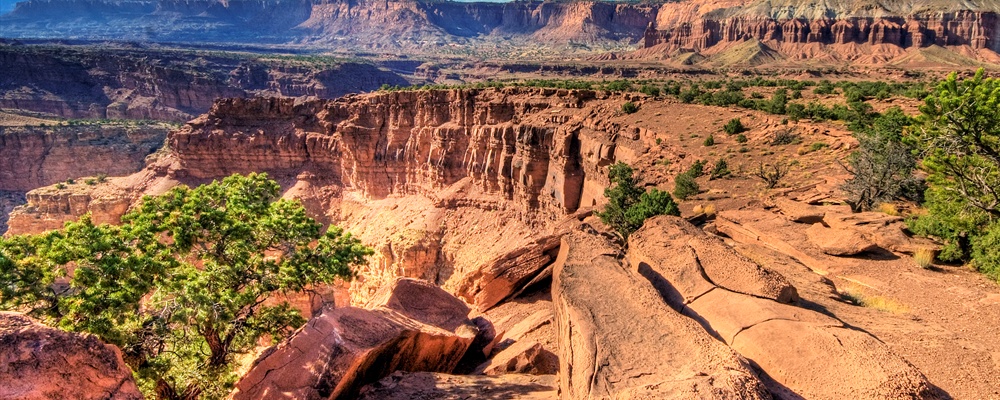
The Waterpocket Fold defines the Park. A 100-mile long warp in the Earth's crust, the Waterpocket Fold is a classic monocline: a regional fold with one very steep side in an area of otherwise nearly horizontal layers. A monocline is a "step-up" in the rock layers. The layers on the west side of the Fold have been lifted more than 7000 feet higher than those on the east. The park was established primarily to preserve the geologic features of the waterpocket fold, such as the scenic rock domes and narrow canyons. Capitol Reef is a geologist's paradise, with nearly 10,000 feet of sedimentary layers ranging from 270 million to 80 million years old. The Waterpocket Fold has tilted this geologic layer cake down to the east, with older rocks in the west and younger ones in the east. Rock layers in Capitol Reef reveal ancient environments as varied as rivers and swamps (Chinle Formation), Sahara-like deserts (Navajo Sandstone), and shallow oceans (Mancos Shale). These layers have been eroded by wind and especially water over the last 20 million years. The landforms are a result of different responses of various rock layers to these forces of erosion. Hard sandstone layers form cliffs, while softer shale layers form slopes and low hills. Black boulders found scattered throughout the park are volcanic rocks from the 20 to 30 million year old lava flows which cap the nearby mountains.
Flora and fauna
The most visible plant life in the park is found in the riparian corridors near Fruita. Along the rivers, you may see cottonwoods and willows as well as the invasive tamarisk. Pioneer orchards along the Fremont River sport apple, apricot, pear, peach, and cherry trees. In the dryer areas of the park, you may see sagebrush, Utah Juniper, various prickly pear cacti, and higher elevations may feature pinyon pine. The cacti, along with some desert wildflowers, bloom briefly in the early spring.
Like many parts of the Utah desert, the nearly barren ground is covered with a biological soil crust, also known as cryptobiotic soil. This collection of bacteria, moss and lichen helps to stabilize loose desert soils and retain precious moisture. These crusts are very fragile, however, and should never be walked or driven on as they may take centuries to regenerate. Do not leave established hiking trails, but if you must, walk in washes or on bare rock.
There are many animals in the park, but, like many desert creatures, they are far more active at night. The park is home to many species of lizards, and a number of snakes. Listen for the sound of Canyon Wrens in the narrow washes; they and many other birds make their home here. Vultures, hawks and the introduced Chukar are common sights in the park. You may be lucky enough to see some of the numerous bat species flying around Fruita in the evening. Deer are an extremely common sight in the orchards and picnic area. Though they may look tame, they are not. Do not feed them or any other animal. Other common large mammals include the Gray Fox, Raccoon, Ringtail, Badger, and Porcupine. The once common Desert Bighorn Sheep were reintroduced in the late 1990's and are thriving. Mountain Lions have also been reported in the park, but are rarely seen by visitors. If you do see one, do not approach it.
Getting there
Traveling westbound on Interstate 70 - Take Utah State Highway 24 west towards Hanksville (exit 149). Stay on Highway 24 for 95 miles to reach the park Visitor Center.
Traveling on Interstate 15 - Take US Highway 50 east at Scipio (exit 188) towards Salina for 30 miles. At the junction with Utah State Highway 89/259, turn right (south) and travel 8 miles. Turn left (east) onto Utah State Highway 24 towards Sigurd. Continue on Highway 24 for 82 miles to reach the park Visitor Center.
Things to do
Hiking
Rim Overlook & Navajo Knobs trail (strenuous, with a fantastic 360° view from the summit)
Sleep
Lodging
Skyridge B&B (in Torrey, very comfortable)
Buy
Historic Gifford Farmhouse, Daily 9:00-4:30, One mile south of Visitor's Center along the Scenic Drive, There is a store inside the kitchen of this historic homestead that sells items handmade by local craftsmen, such as quilts, soap, candles and toys as well more typical souvenirs like books, and postcards. The highlight is the locally made foodstuff such as jams, pickles, and excellent homemade fruit pies.
Safety
Flash floods can occur in the park without warning. The danger is especially high when walking in narrow slot canyons such as Grand Wash. Although rainstorms in the park are beautiful, it's not a safe time to be on the trails. Flood waters originate upstream, so a flood may occur from a storm that is miles away. If you are in a narrow canyon and the water begins to rise even slightly or the wash begins to get muddy, begin looking for higher ground.
Fees/Permits
The park and campgrounds are open year round. The Visitor Center is open daily (except for some major holidays) from 8:00 a.m. to 4:30 p.m. with extended hours during the summer season.
Ripple Rock Nature Center is open from Memorial Day through Labor Day from 10:00 a.m. to 3:00 p.m. Tuesday through Saturday, closed Sundays and Mondays.
The following Entrance Fees are charged for traveling the park’s Scenic Drive beyond the Fruita Campground.
Individuals: $3.00 (Good for 7 days) This fee applies to bicycles and pedestrians (per person).
Vehicles: $5.00 (Good for 7 days) This fee applies to private vehicles, including motorcycles.
Entrance Fee Waivers: Fee waivers are available for groups traveling the Scenic Drive for educational purposes. Fee waiver requests must be submitted two weeks prior to your visit.
Sites at the Fruita Campground are $10 per night. Senior and Access pass holders receive a 50% discount on their campsite.
Get out
Heading west out of the park and about 40 miles south on the incredibly scenic Highway 12 will take you to the town of Boulder, Utah, home of Anasazi State Park which details the historic Native American tribes of Southern Utah. Travelling another 60 miles south on Hwy 12 will bring you to Bryce Canyon National Park.
Heading East on Hwy 24 and South on Hwy 95, (about 80 miles) will bring you to Glen Canyon National Recreation Area. Alternately, the adventurous can reach Bullfrog marina in Glen Canyon NRA by driving south on the unimproved Notom Road, but check road conditions at the Visitor Center.
Travelling east on Hwy 24 and North on Hwy 95 about 55 miles will bring you to the turn off to Goblin Valley State Park.
Contact & location
Be the first one to add a review
The photos displayed on this page are the property of one of the following authors:
Capitol Reef National Park is a United States National Park, in Utah's Canyon Country.
Understand
Capitol Reef is a National Park comprising 378 square miles of sandstone canyons, ridges, buttes, and monoliths. The Park is defined by the Waterpocket Fold, a 100-mile long wrinkle in the earth's crust known as a monocline. The Fold extends from nearby Thousand Lakes Mountain to the Colorado River (now Lake Powell). Capitol Reef National Park was established to protect this grand and colorful geologic feature, as well as the unique natural and cultural history found in the area. The name was derived from the rounded sandstone buttes which resemble capitol domes and from the long line of rocky cliffs which are a barrier to travel, like a coral reef.
History
From the 9th to 15th centuries, Native Americans of the Fremont Culture lived in and near the Waterpocket Fold. They seem to have left the region around 1500 for unknown reasons. Later, nomadic Ute and Southern Paiute tribes inhabited the area. Explorer John C. Fremont passed throught the northern part of what is now Capitol Reef in 1854. The Fremont River that runs through the park is named after him.
White settlement came late to the area, in the 1870's, Latter Day Saints (Mormon) settlers moved into the high plateau lands west of Capitol Reef and established communities based on short-season farming and grazing. In the 1880's Mormon settlers moved into Capitol Reef and established the community of Fruita along the banks of the Fremont River. These settlers planted the fruit orchards along the river that still exist today. No more than 10 families at any one time lived in the Fruita area.
The area was called "Wayne Wonderland" in the 1920s by local boosters Ephraim P. Pectol and Joseph S. Hickman, and in 1937, President Roosevelt set aside a portion of Wayne Wonderland as a National Monument. Funds for the park were scarce, however, and it would be a long time before the first rangers would arrive. During the 1960's, a campground, visitor center and staff housing were built and a road through the park was paved. During this period, most of the farmers in the area left and sold their land to the Park Service. In 1968, a large amount of land was added to the park, increasing it's size by almost 600%, and in 1971 the National Monumnent officially became Capitol Reef National Park.
Climate
Summer temperatures often climb into the upper 90s(F), but nights cool down into the 50s(F) and 60s(F). The thunderstorm season from July through September brings cloudbursts, flash floods and lightning. Spring and fall are milder with highs generally in the 50s(F) and 60s(F). Daytime winter highs average less than 50(F). Snowfall is usually light, especially at lower elevations. Humidity is low all year.
Landscape
Travellers to the park experience a dazzling landscape of rock formations. From colorful domes, high cliffs, and towering spires of sandstone to arches, natural bridges, and narrow slot canyons. The desert streams, such as the Fremont, wind through the Park, carving deep canyons and meandering through floodplains surrounded by narrow ribbons of greenery.
The Waterpocket Fold defines the Park. A 100-mile long warp in the Earth's crust, the Waterpocket Fold is a classic monocline: a regional fold with one very steep side in an area of otherwise nearly horizontal layers. A monocline is a "step-up" in the rock layers. The layers on the west side of the Fold have been lifted more than 7000 feet higher than those on the east. The park was established primarily to preserve the geologic features of the waterpocket fold, such as the scenic rock domes and narrow canyons. Capitol Reef is a geologist's paradise, with nearly 10,000 feet of sedimentary layers ranging from 270 million to 80 million years old. The Waterpocket Fold has tilted this geologic layer cake down to the east, with older rocks in the west and younger ones in the east. Rock layers in Capitol Reef reveal ancient environments as varied as rivers and swamps (Chinle Formation), Sahara-like deserts (Navajo Sandstone), and shallow oceans (Mancos Shale). These layers have been eroded by wind and especially water over the last 20 million years. The landforms are a result of different responses of various rock layers to these forces of erosion. Hard sandstone layers form cliffs, while softer shale layers form slopes and low hills. Black boulders found scattered throughout the park are volcanic rocks from the 20 to 30 million year old lava flows which cap the nearby mountains.
Flora and fauna
The most visible plant life in the park is found in the riparian corridors near Fruita. Along the rivers, you may see cottonwoods and willows as well as the invasive tamarisk. Pioneer orchards along the Fremont River sport apple, apricot, pear, peach, and cherry trees. In the dryer areas of the park, you may see sagebrush, Utah Juniper, various prickly pear cacti, and higher elevations may feature pinyon pine. The cacti, along with some desert wildflowers, bloom briefly in the early spring. Like many parts of the Utah desert, the nearly barren ground is covered with a biological soil crust, also known as cryptobiotic soil. This collection of bacteria, moss and lichen helps to stabilize loose desert soils and retain precious moisture. These crusts are very fragile, however, and should never be walked or driven on as they may take centuries to regenerate. Do not leave established hiking trails, but if you must, walk in washes or on bare rock. There are many animals in the park, but, like many desert creatures, they are far more active at night. The park is home to many species of lizards, and a number of snakes. Listen for the sound of Canyon Wrens in the narrow washes; they and many other birds make their home here. Vultures, hawks and the introduced Chukar are common sights in the park. You may be lucky enough to see some of the numerous bat species flying around Fruita in the evening. Deer are an extremely common sight in the orchards and picnic area. Though they may look tame, they are not. Do not feed them or any other animal. Other common large mammals include the Gray Fox, Raccoon, Ringtail, Badger, and Porcupine. The once common Desert Bighorn Sheep were reintroduced in the late 1990's and are thriving. Mountain Lions have also been reported in the park, but are rarely seen by visitors. If you do see one, do not approach it.
Getting there
Traveling westbound on Interstate 70 - Take Utah State Highway 24 west towards Hanksville (exit 149). Stay on Highway 24 for 95 miles to reach the park Visitor Center.
Traveling on Interstate 15 - Take US Highway 50 east at Scipio (exit 188) towards Salina for 30 miles. At the junction with Utah State Highway 89/259, turn right (south) and travel 8 miles. Turn left (east) onto Utah State Highway 24 towards Sigurd. Continue on Highway 24 for 82 miles to reach the park Visitor Center.
Things to do
Hiking
Sleep
Lodging
Buy
Safety
Flash floods can occur in the park without warning. The danger is especially high when walking in narrow slot canyons such as Grand Wash. Although rainstorms in the park are beautiful, it's not a safe time to be on the trails. Flood waters originate upstream, so a flood may occur from a storm that is miles away. If you are in a narrow canyon and the water begins to rise even slightly or the wash begins to get muddy, begin looking for higher ground.
Fees/Permits
The park and campgrounds are open year round. The Visitor Center is open daily (except for some major holidays) from 8:00 a.m. to 4:30 p.m. with extended hours during the summer season.
Ripple Rock Nature Center is open from Memorial Day through Labor Day from 10:00 a.m. to 3:00 p.m. Tuesday through Saturday, closed Sundays and Mondays.
The following Entrance Fees are charged for traveling the park’s Scenic Drive beyond the Fruita Campground.
Individuals: $3.00 (Good for 7 days) This fee applies to bicycles and pedestrians (per person).
Vehicles: $5.00 (Good for 7 days) This fee applies to private vehicles, including motorcycles.
Entrance Fee Waivers: Fee waivers are available for groups traveling the Scenic Drive for educational purposes. Fee waiver requests must be submitted two weeks prior to your visit.
Sites at the Fruita Campground are $10 per night. Senior and Access pass holders receive a 50% discount on their campsite.
Get out
Heading west out of the park and about 40 miles south on the incredibly scenic Highway 12 will take you to the town of Boulder, Utah, home of Anasazi State Park which details the historic Native American tribes of Southern Utah. Travelling another 60 miles south on Hwy 12 will bring you to Bryce Canyon National Park.
Heading East on Hwy 24 and South on Hwy 95, (about 80 miles) will bring you to Glen Canyon National Recreation Area. Alternately, the adventurous can reach Bullfrog marina in Glen Canyon NRA by driving south on the unimproved Notom Road, but check road conditions at the Visitor Center.
Travelling east on Hwy 24 and North on Hwy 95 about 55 miles will bring you to the turn off to Goblin Valley State Park.
Contact & location
Be the first one to add a review
The photos displayed on this page are the property of one of the following authors:
Wolfgang Staudt, Edward Wang, Ken Lund
Some photos courtesy of: . The photos provided by Flickr are under the copyright of their owners.
This travel guide also includes text from Wikitravel articles, all available at View full credits
Inas, Matt, Peter Fitzgerald, Philippe Malarme and M. Hogue.
This travel guide also includes text from Wikipedia articles, all available at View full credits