Olympic National Park is a UNESCO World Heritage Site located in Washington State.
Understand
History
Olympic National Monument was established in 1909 and up-graded to the status of national park in 1938. It was further designated as an International Biosphere Reserve in 1976, and evolved into a World Heritage Park in 1981. Currently, nearly 96% the Olympic National Park is incorporated into the Olympic Wilderness.
Climate
Overall, the Olympic Peninsula has a moderate marine climate with pleasant summers and mild, wet winters. The Olympic Mountains, part of North America's western coast range, rise suddenly from near sea level to ~8000 feet, intercepting Pacific moisture which is dumped as large amounts of rain. The climate grows wetter from east to west on the Olympic Peninsula. Sunny days are likeliest in July and August. Nearby Sequim is actually in the rain-shadow of the Olympics and is known for sunny days and minimal rain.
Summers tend to be fair and warm, with high temperatures between 65 and 75 degrees F. July, August and September are the driest months, with heavier precipitation during the rest of the year.
While winters are mild at lower elevation, with temperatures in the 30's and 40's, snowfall can be heavy in the mountains, with accumulations of up to 10 feet common.
Flora and fauna
Enormous Sitka spruce and Douglas fir, hundreds of feet high, in the Hoh and Queets rain forest valleys on the west side of the park. Thick, furry epiphyte moss and dense, vibrant vegetation give a beautiful, almost "Tolkien-esqe" environment in these unique temperate rain forests, which receive fifteen feet of rain per year on average from the nearby Pacific Ocean.
Getting there
You will want a car to explore Olympic National Park. Unlike many national parks, there are no roads through the park. In fact, the central part of the park is one of the last great roadless patches in the lower 48 states. There are a number of roads running from US 101 into the park: Hurricane Ridge, Elwha, Sol Doc, Hoh, and Quinault. The park also includes much of the Pacific coast along the peninsula which is accessible from US 101 at Klalaloch, La Push, Cape Alava and Neah Bay. The park is a big park, so think about your trip, and take driving times into account. You don't want to spend all your time on the road.
There are a number of ways of getting to Olympic National Park by car:
From Seattle or Seatac - head south to Tacoma and cross the Tacoma Narrows to the peninsula
From Seattle - take the Bainbridge Island or Bremerton ferry
From north of Seattle - take the Edmonds ferry to Kingston and continue west
From Anacortes or Whidbey Island - take the Keystone ferry from Whidbey Island to Port Townsend and continue west
From Olympia or points south along the I-5 corridor (including Portland) - take US 101 north along the Hood Canal
from points south on the coast, following the coast - take US 101 north through Aberdeen and near Ocean Shores
from Vancouver or Victoria, BC - take the Coho ferry from Victoria
Most of the ferries are run by the Washington State Department of Transportation, but the Coho ferry and the Victoria Express are run privately.
Be warned that the ferries can be backed up for two or three hours, particularly in the summer when people are heading off or returning from their vacations on the Olympic Peninsula. If you can, avoid heading west on Friday afternoons and east on Sunday evenings. The ferries usually run roughly every 50 minutes and can offer a relaxing way to cross Puget Sound.
I-5, the main road from Seattle to Tacoma can be crowded during rush hour (6-9 AM and 4-7 PM). You can check traffic conditions, and for other travel problems, at the state DOT web site .
There are scheduled flights to Port Angeles, so you can approach by air. The views of the Olympics are often fantastic, and you can arrange to rent a car at the airport.
from Boeing Field (BFI) near Seattle - take a scheduled Kenmore Air flight to Fairchild Airport (CLM)
Another approach is to fly to Victoria, BC (YYJ), then take the Coho ferry or the Victoria Express to Port Angeles and rent a car there.
from Victoria, BC - fly to Victoria, rent a car there, or take the ferry across the Strait of San Juan de Fuca and rent a car in the U.S.
See
Hoh Rainforest. 12 miles or so on Upper Hoh road heading east from US101 on the west coast of the Olympic peninsula. There are several small, presumably dirt roads heading into the area. They are probably old logging roads, and might not be kept up at all. Considering the amount of rainfall in the area, these roads might only be passable with a high clearance off-highway vehicle. There is one stop for gas and snack food, film, etc. on Upper Hoh before the park entrance. 6 miles from the parking lot is the gate house which is unstaffed in the winter and the entrance fee can be donated in the unstaffed visitor center. Watch for herds of elk in the area, roll down the window (even if it is raining) and take in the smell of what seems a recently drained underwater world. Grab a map at the visitor's center or just head straight to the 2 trails.
It is an 18-mile hike from the Hoh Visitor Center to the summit of Mt. Olympus with its glacier fields (the last five miles being steepest). Trails are well-maintained but good hiking boots and gear are recommended.
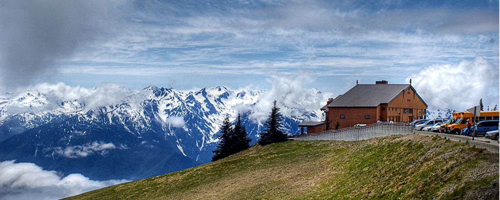
Hurricane Ridge
Lake Crescent
The Coastal Strip Accessed from Kalacoch, La Push, Ozette or Neah Bay, this strech of mostly wilderness coastline is extremely spectacular.
Lake Quinault
Things to do
Hall of Moss Trail. This mile and a half stroll crosses a small creek and up to an older grove of trees. Western Hemlock, Douglas Firs, bigleaf maple, western cedar, red alder, vine maple, black cottonwood, and the sitka Spruce live together with a slew of different Epiphytes-- plants which live on other plants.
Beaches. There are numerous beaches that can be visited, most are simply numbered, i.e. Beach trail 3. Ruby beach is one exception, which also happens to be very hard to get to. This makes Ruby beach one of many ideal locations to visit if you are seeking solitude while you enjoy nature. Despite the small populations in this part of the state, some of the beaches can be quite crowded during a small period in the summer months (usually 3 weeks or so in late June and early July), with fishermen, clamers, and screaming children.
Hiking and Backpacking The Olympic National Park has a very extensive trail system, both through the interior and along the coast. Much of the interior and the coast is wilderness and can only be seen from the trails.
Sleep
Lodging
Kalaloch LodgeKalaloch is a lodge located on a bluff, just above a beach. The lodge has been in existence for many years, but has recently undergone renovations and become much more tourist friendly. This being said, the view from the lodge is still one of the best in the area, overlooking the pacific ocean. There are cabins available for rent, which are quite expensive, but are the only places to sleep indoors in the area. These cabins are very nice, and well maintained. If a large group of people are traveling together, then it may be a fun thing to do to rent one.
Lake Quinault Lodge
Sol Duc Hotsprings
Lake Crescent Lodge
Olympic Lodge
Rain Forest Resort Village
Olympic Suites Inn
Safety
The most dangerous thing around this area are drunk drivers. The roads are small, perpetually wet, winding, and not banked, so driving too fast can be incredibly dangerous.
The wildlife can also be somewhat hazardous, although with a bit of common sense, most danger can be avoided. This is bear country, so make noise if you are travelling in an area with limited visibility (most of this area has very poor visibility, due to the extreme amounts of vegetation.) Also, cougars do live in Olympic National park, and are much more aggressive and dangerous than bears. That being said, the number of incidents involving mountain lions is very small, so there isn't too much to worry about. Another animal that needs to be watched out for are the elk. Although elk are herd animals, and not aggressive like their moose cousins, they can be extremely dangerous if they feel threatened. Only an idiot would threaten a herd of 50 elk though, so if you are not an idiot, you will be safe from these animals. (And if you are an idiot, then you get to take part in one of the most ancient aspects of nature - natural selection.)
Get Around
By car is really the only way in or out. US-101 makes a loop of the Olympic Peninsula, but only some spur roads actually lead into the park. The interior is roadless and is only accesible to backpackers. Most people visit either the park's beach section, which is accessible only on US-101 between Forks and Aberdeen, or Hurricane Ridge, which is accessed from a road out of Port Angeles.
Access points from the more remote east side are Staircase (turn west off 101 in Hoodsport) or Quilcene (closer to the Hood Canal Bridge).
The best way to see the park is to drive from Aberdeen on northbound US-101 and "do the loop", ending in Olympia, taking three or four days to visit the coastal section (Kalaloch Campground or Lodge are great places to stay), the rainforest (Hoh), Ozette (an easy three mile hike in, or do the easy nine mile loop, tides permitting), Lake Cresent, Hurricane Ridge, and Staircase.
Campground reservations are recommended in the summer.
Victoria With a ferry connecting it from Port Angeles, this city famous for its British charm can easily be done as a day-trip from Olympic National Park.
Contact & location
Be the first one to add a review
The photos displayed on this page are the property of one of the following authors:
Some photos courtesy of:
. The photos provided by Flickr are under the copyright of their owners.
This travel guide also includes text from Wikitravel articles, all available at View full credits
Paul G, Peter Fitzgerald, The Kalebergs, Ryan Holliday, Andrew Haggard, Nick Roux, Dan Abbott, Curtis Cosens and Michele Ann Jenkins, Tatatabot, Rodericoco, WindHorse and Tim Andonian
This travel guide also includes text from Wikipedia articles, all available at View full credits

Olympic National Park is a UNESCO World Heritage Site located in Washington State.
Understand
History
Olympic National Monument was established in 1909 and up-graded to the status of national park in 1938. It was further designated as an International Biosphere Reserve in 1976, and evolved into a World Heritage Park in 1981. Currently, nearly 96% the Olympic National Park is incorporated into the Olympic Wilderness.
Climate
Overall, the Olympic Peninsula has a moderate marine climate with pleasant summers and mild, wet winters. The Olympic Mountains, part of North America's western coast range, rise suddenly from near sea level to ~8000 feet, intercepting Pacific moisture which is dumped as large amounts of rain. The climate grows wetter from east to west on the Olympic Peninsula. Sunny days are likeliest in July and August. Nearby Sequim is actually in the rain-shadow of the Olympics and is known for sunny days and minimal rain.
Summers tend to be fair and warm, with high temperatures between 65 and 75 degrees F. July, August and September are the driest months, with heavier precipitation during the rest of the year.
While winters are mild at lower elevation, with temperatures in the 30's and 40's, snowfall can be heavy in the mountains, with accumulations of up to 10 feet common.
Flora and fauna
Enormous Sitka spruce and Douglas fir, hundreds of feet high, in the Hoh and Queets rain forest valleys on the west side of the park. Thick, furry epiphyte moss and dense, vibrant vegetation give a beautiful, almost "Tolkien-esqe" environment in these unique temperate rain forests, which receive fifteen feet of rain per year on average from the nearby Pacific Ocean.
Getting there
You will want a car to explore Olympic National Park. Unlike many national parks, there are no roads through the park. In fact, the central part of the park is one of the last great roadless patches in the lower 48 states. There are a number of roads running from US 101 into the park: Hurricane Ridge, Elwha, Sol Doc, Hoh, and Quinault. The park also includes much of the Pacific coast along the peninsula which is accessible from US 101 at Klalaloch, La Push, Cape Alava and Neah Bay. The park is a big park, so think about your trip, and take driving times into account. You don't want to spend all your time on the road.
There are a number of ways of getting to Olympic National Park by car:
From Seattle or Seatac - head south to Tacoma and cross the Tacoma Narrows to the peninsula
From Seattle - take the Bainbridge Island or Bremerton ferry
From north of Seattle - take the Edmonds ferry to Kingston and continue west
From Anacortes or Whidbey Island - take the Keystone ferry from Whidbey Island to Port Townsend and continue west
From Olympia or points south along the I-5 corridor (including Portland) - take US 101 north along the Hood Canal
from points south on the coast, following the coast - take US 101 north through Aberdeen and near Ocean Shores
from Vancouver or Victoria, BC - take the Coho ferry from Victoria
Most of the ferries are run by the Washington State Department of Transportation, but the Coho ferry and the Victoria Express are run privately.
Be warned that the ferries can be backed up for two or three hours, particularly in the summer when people are heading off or returning from their vacations on the Olympic Peninsula. If you can, avoid heading west on Friday afternoons and east on Sunday evenings. The ferries usually run roughly every 50 minutes and can offer a relaxing way to cross Puget Sound.
I-5, the main road from Seattle to Tacoma can be crowded during rush hour (6-9 AM and 4-7 PM). You can check traffic conditions, and for other travel problems, at the state DOT web site .
There are scheduled flights to Port Angeles, so you can approach by air. The views of the Olympics are often fantastic, and you can arrange to rent a car at the airport.
Another approach is to fly to Victoria, BC (YYJ), then take the Coho ferry or the Victoria Express to Port Angeles and rent a car there.
See
It is an 18-mile hike from the Hoh Visitor Center to the summit of Mt. Olympus with its glacier fields (the last five miles being steepest). Trails are well-maintained but good hiking boots and gear are recommended.
Hurricane Ridge
Lake Crescent
The Coastal Strip Accessed from Kalacoch, La Push, Ozette or Neah Bay, this strech of mostly wilderness coastline is extremely spectacular.
Lake Quinault
Things to do
Hall of Moss Trail. This mile and a half stroll crosses a small creek and up to an older grove of trees. Western Hemlock, Douglas Firs, bigleaf maple, western cedar, red alder, vine maple, black cottonwood, and the sitka Spruce live together with a slew of different Epiphytes-- plants which live on other plants.
Beaches. There are numerous beaches that can be visited, most are simply numbered, i.e. Beach trail 3. Ruby beach is one exception, which also happens to be very hard to get to. This makes Ruby beach one of many ideal locations to visit if you are seeking solitude while you enjoy nature. Despite the small populations in this part of the state, some of the beaches can be quite crowded during a small period in the summer months (usually 3 weeks or so in late June and early July), with fishermen, clamers, and screaming children.
Hiking and Backpacking The Olympic National Park has a very extensive trail system, both through the interior and along the coast. Much of the interior and the coast is wilderness and can only be seen from the trails.
Sleep
Lodging
Kalaloch Lodge Kalaloch is a lodge located on a bluff, just above a beach. The lodge has been in existence for many years, but has recently undergone renovations and become much more tourist friendly. This being said, the view from the lodge is still one of the best in the area, overlooking the pacific ocean. There are cabins available for rent, which are quite expensive, but are the only places to sleep indoors in the area. These cabins are very nice, and well maintained. If a large group of people are traveling together, then it may be a fun thing to do to rent one.
Lake Quinault Lodge
Sol Duc Hotsprings
Lake Crescent Lodge
Olympic Lodge
Rain Forest Resort Village
Olympic Suites Inn
Safety
The most dangerous thing around this area are drunk drivers. The roads are small, perpetually wet, winding, and not banked, so driving too fast can be incredibly dangerous.
The wildlife can also be somewhat hazardous, although with a bit of common sense, most danger can be avoided. This is bear country, so make noise if you are travelling in an area with limited visibility (most of this area has very poor visibility, due to the extreme amounts of vegetation.) Also, cougars do live in Olympic National park, and are much more aggressive and dangerous than bears. That being said, the number of incidents involving mountain lions is very small, so there isn't too much to worry about. Another animal that needs to be watched out for are the elk. Although elk are herd animals, and not aggressive like their moose cousins, they can be extremely dangerous if they feel threatened. Only an idiot would threaten a herd of 50 elk though, so if you are not an idiot, you will be safe from these animals. (And if you are an idiot, then you get to take part in one of the most ancient aspects of nature - natural selection.)
Get Around
By car is really the only way in or out. US-101 makes a loop of the Olympic Peninsula, but only some spur roads actually lead into the park. The interior is roadless and is only accesible to backpackers. Most people visit either the park's beach section, which is accessible only on US-101 between Forks and Aberdeen, or Hurricane Ridge, which is accessed from a road out of Port Angeles.
Access points from the more remote east side are Staircase (turn west off 101 in Hoodsport) or Quilcene (closer to the Hood Canal Bridge).
The best way to see the park is to drive from Aberdeen on northbound US-101 and "do the loop", ending in Olympia, taking three or four days to visit the coastal section (Kalaloch Campground or Lodge are great places to stay), the rainforest (Hoh), Ozette (an easy three mile hike in, or do the easy nine mile loop, tides permitting), Lake Cresent, Hurricane Ridge, and Staircase.
Campground reservations are recommended in the summer.
Port Angeles
Sequim
Seattle
Victoria With a ferry connecting it from Port Angeles, this city famous for its British charm can easily be done as a day-trip from Olympic National Park.
Contact & location
Be the first one to add a review
The photos displayed on this page are the property of one of the following authors:
Bala, Frank Kovalchek, ((brian)), Jason Pratt, pfly
Some photos courtesy of: . The photos provided by Flickr are under the copyright of their owners.
This travel guide also includes text from Wikitravel articles, all available at View full credits
Paul G, Peter Fitzgerald, The Kalebergs, Ryan Holliday, Andrew Haggard, Nick Roux, Dan Abbott, Curtis Cosens and Michele Ann Jenkins, Tatatabot, Rodericoco, WindHorse and Tim Andonian
This travel guide also includes text from Wikipedia articles, all available at View full credits