Mono Lake is in Eastern Sierra region of California in the United States, just east of Yosemite National Park. The lake is a saline lake with no outlets and is also a stopover point for nearly two million migratory birds.
Understand
History
Starting in 1941 the streams that fed Mono Lake were diverted for use by the city of Los Angeles. With a yearly evaporation rate of 45 inches (nearly four feet) the lake level quickly dropped, going from an elevation of 6,417 feet above sea level to a low point of 6,372 feet above sea level. The accompanying 31% loss of surface area and 50% loss of water volume had a devastating effect on the estimated two million birds that used the lake each year, as well as causing air quality problems due to the dust from the now-exposed lakebed. In 1994 a court ordered that the lake be returned to a level of 6,392 feet above sea level, but due to droughts in the region the current (2008) level is still only 6,382 feet above sea level.
Climate
With little more than desert scrub in the basin, there is no shelter from the elements.
Winds routinely rip through the basin in all seasons. Choking alkali dust clouds can be lifted out of basin by the winds. Usually, the wind direction sends these clouds out to the east away from the most visited parts, but there's no guarantee that the direction won't change and provide you with a much more intimate opportunity to study the clouds firsthand.
In winter, snow occasionally covers the ground. Chains may be required to get around the basin, and are frequently required to cross the passes to get in and out of the region. State Route 120 is closed just west of US 395 all winter (and often all spring), and is closed east of the South Tufa area for much of the winter too.
In summer, if the wind stops suddenly, a cold day can suddenly turn into a scorcher.
Landscape
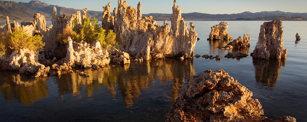
The lake is believed to have formed 760,000 years ago, although it may be a remnant of a larger lake that formed 1-3 million years ago, thus making it one of the oldest lakes in North America. It is a saline lake with no outlets, fed solely by runoff from the surrounding mountains. One unusual feature of the lake is its many tufa rock formations. These rock towers form when underwater springs rich in calcium mix with the waters of the lake, which are rich in carbonates. The resulting reaction forms limestone. Over time the buildup of limestone forms a tower, and with the drop in lake level the towers have become exposed.
Flora and fauna
Mono Lake is a noted birdwatching destination. Brine shrimp and brine fly larva in the water and brine flies on the shorelines provide abundant food for hungry migrants that stopover to refuel before moving on. Additionally, despite the fact that Negit Island has become land-bridged (and thus accessible to predators) due to lake level decrease, the area's islands remain important breeding areas for birds. Approximately 85% of the state's population of California gulls cross the Sierras each year to breed here, as well as a significant portion of the state's snowy plovers. In addition, between 1.5 to 2 million eared grebes use the lake during migration each year, as well as 80,000 Wilson's phalaropes, 60,000 red-necked phalaropes, and nearly 80 other species of waterbirds.
The lake's food chain begins with algae that bloom in summer months. This algae becomes food for the 4-6 trillion brine shrimp that inhabit the lake, as well as the brine flies that gather on the shoreline. In summer months these flies rise up in black clouds when approached, although luckily they aren't biting insects and thus are not a nuisance to humans.
Getting there
The primary access to Mono Lake is provided by Highway 395, which runs north and south along the Eastern Sierra. During the summer months the lake can also be reached from Yosemite National Park using Highway 120 (Tioga Pass), but this route closes with the year's first snowfall and doesn't re-open until the following May or June.
See
Mono Lake Tufa SNR, The state reserve includes areas of the lake with the largest tufa towers. The section of the reserve located below the Mono County Park offers a boardwalk featuring interpretive information.
Things to do
Boating
Mono Lake can be a challenging environment for boaters - the high salt content of the lake, strong winds, and submerged rock formations combine to test the skills of boaters. Most boaters exit the lake by early afternoon to avoid the rough winds that are common. Due to the lake conditions, canoes and kayaks are the most popular types of craft for venturing out on the lake. Boaters should also be aware that from April 1 through August 1 the lake's islands are closed to protect nesting birds.
Caldera Kayaks, +1-760-934-1691, +1-760-934-1691, Offers guided morning kayak tours during the summer leaving from Navy Beach. Call or write in advance to set up a trip.
Nature
Naturalist-led walks are offered daily in the summer by the forest service, the state reserve staff, and the Mono Lake Committee. In addition, the Mono Lake Committee offers three-day seminars covering topics from geology, human history, and wildlife of the Mono Lake area.
Eat
There is a very popular restaurant at the corner of highway 120 and 395 that is part of a Mobile Gas station. Given the remoteness it is quite nice and recently remodeled. On a weeknight expect to see as many as 30 other diners enjoying the views overlooking the lake. Food is standard grill fare, and due to the somewhat limited off-season options this stop may be the best bet in the area.
Drink
Drinking water is available at the visitor centers. For stronger fare the town of Lee Vining has seasonal options.
Sleep
Since this is a preserve, no camping is permitted anywhere within the Mono Lake Scenic Area.
Lodging
Lodging is available within the city of Lee Vining, some of which overlook the lake.
Camping
Big Bend Campground, Season varies, but generally open Apr 26-Oct 15, take SR120 west from US395, then left onto Poole Power Plant Road which leads up the canyon to the campground, In a stand of trees next to the creek in Lee Vining canyon. Several other campgrounds are in the same canyon.
Buy
Supplies and other necessities can be purchased in the town of Lee Vining. Gas is available year-round, but many establishments are open only during the summer season.
Fees/Permits
There are no fees charged to visit Mono Lake.
Lee Vining. Located along the lake shore, this town offers services and information about the lake.
Yosemite National Park. The Tioga Pass entrance to the park is located just south of the lake, but is closed from the first snow until the roads can be cleared in the Spring (usually around May).
Contact & location
Be the first one to add a review
The photos displayed on this page are the property of one of the following authors:

Mono Lake is in Eastern Sierra region of California in the United States, just east of Yosemite National Park. The lake is a saline lake with no outlets and is also a stopover point for nearly two million migratory birds.
Understand
History
Starting in 1941 the streams that fed Mono Lake were diverted for use by the city of Los Angeles. With a yearly evaporation rate of 45 inches (nearly four feet) the lake level quickly dropped, going from an elevation of 6,417 feet above sea level to a low point of 6,372 feet above sea level. The accompanying 31% loss of surface area and 50% loss of water volume had a devastating effect on the estimated two million birds that used the lake each year, as well as causing air quality problems due to the dust from the now-exposed lakebed. In 1994 a court ordered that the lake be returned to a level of 6,392 feet above sea level, but due to droughts in the region the current (2008) level is still only 6,382 feet above sea level.
Climate
With little more than desert scrub in the basin, there is no shelter from the elements.
Winds routinely rip through the basin in all seasons. Choking alkali dust clouds can be lifted out of basin by the winds. Usually, the wind direction sends these clouds out to the east away from the most visited parts, but there's no guarantee that the direction won't change and provide you with a much more intimate opportunity to study the clouds firsthand.
In winter, snow occasionally covers the ground. Chains may be required to get around the basin, and are frequently required to cross the passes to get in and out of the region. State Route 120 is closed just west of US 395 all winter (and often all spring), and is closed east of the South Tufa area for much of the winter too.
In summer, if the wind stops suddenly, a cold day can suddenly turn into a scorcher.
Landscape
The lake is believed to have formed 760,000 years ago, although it may be a remnant of a larger lake that formed 1-3 million years ago, thus making it one of the oldest lakes in North America. It is a saline lake with no outlets, fed solely by runoff from the surrounding mountains. One unusual feature of the lake is its many tufa rock formations. These rock towers form when underwater springs rich in calcium mix with the waters of the lake, which are rich in carbonates. The resulting reaction forms limestone. Over time the buildup of limestone forms a tower, and with the drop in lake level the towers have become exposed.
Flora and fauna
Mono Lake is a noted birdwatching destination. Brine shrimp and brine fly larva in the water and brine flies on the shorelines provide abundant food for hungry migrants that stopover to refuel before moving on. Additionally, despite the fact that Negit Island has become land-bridged (and thus accessible to predators) due to lake level decrease, the area's islands remain important breeding areas for birds. Approximately 85% of the state's population of California gulls cross the Sierras each year to breed here, as well as a significant portion of the state's snowy plovers. In addition, between 1.5 to 2 million eared grebes use the lake during migration each year, as well as 80,000 Wilson's phalaropes, 60,000 red-necked phalaropes, and nearly 80 other species of waterbirds.
The lake's food chain begins with algae that bloom in summer months. This algae becomes food for the 4-6 trillion brine shrimp that inhabit the lake, as well as the brine flies that gather on the shoreline. In summer months these flies rise up in black clouds when approached, although luckily they aren't biting insects and thus are not a nuisance to humans.
Getting there
The primary access to Mono Lake is provided by Highway 395, which runs north and south along the Eastern Sierra. During the summer months the lake can also be reached from Yosemite National Park using Highway 120 (Tioga Pass), but this route closes with the year's first snowfall and doesn't re-open until the following May or June.
See
Things to do
Boating
Mono Lake can be a challenging environment for boaters - the high salt content of the lake, strong winds, and submerged rock formations combine to test the skills of boaters. Most boaters exit the lake by early afternoon to avoid the rough winds that are common. Due to the lake conditions, canoes and kayaks are the most popular types of craft for venturing out on the lake. Boaters should also be aware that from April 1 through August 1 the lake's islands are closed to protect nesting birds.
Nature
Naturalist-led walks are offered daily in the summer by the forest service, the state reserve staff, and the Mono Lake Committee. In addition, the Mono Lake Committee offers three-day seminars covering topics from geology, human history, and wildlife of the Mono Lake area.
Eat
There is a very popular restaurant at the corner of highway 120 and 395 that is part of a Mobile Gas station. Given the remoteness it is quite nice and recently remodeled. On a weeknight expect to see as many as 30 other diners enjoying the views overlooking the lake. Food is standard grill fare, and due to the somewhat limited off-season options this stop may be the best bet in the area.
Drink
Drinking water is available at the visitor centers. For stronger fare the town of Lee Vining has seasonal options.
Sleep
Since this is a preserve, no camping is permitted anywhere within the Mono Lake Scenic Area.
Lodging
Lodging is available within the city of Lee Vining, some of which overlook the lake.
Camping
Buy
Supplies and other necessities can be purchased in the town of Lee Vining. Gas is available year-round, but many establishments are open only during the summer season.
Fees/Permits
There are no fees charged to visit Mono Lake.
Lee Vining. Located along the lake shore, this town offers services and information about the lake.
Yosemite National Park. The Tioga Pass entrance to the park is located just south of the lake, but is closed from the first snow until the roads can be cleared in the Spring (usually around May).
Contact & location
Be the first one to add a review
The photos displayed on this page are the property of one of the following authors:
Brent Pearson, Rupert Ganzer, Frank Kovalchek, Linda Tanner, Ron Reiring, Clinton Steeds, Roger H. Goun, Nazhiyath Vijayan, Chris Streeter
Some photos courtesy of: . The photos provided by Flickr are under the copyright of their owners.
This travel guide also includes text from Wikitravel articles, all available at View full credits
Ryan Holliday, Colin Jensen, Bill Johnson, Jim Logan and Geoff McQuilkin
This travel guide also includes text from Wikipedia articles, all available at View full credits