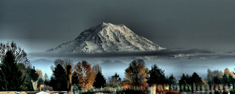
Mount Rainier National Park is a United States National Park located in the American state of Washington, some 54 miles (87 km) south-east of Seattle. Established in 1899 and 368 miles² / 235,625 acres (954 km²) in size, the National Park is centered on the spectacular cone of Mount Rainier, a dormant volcano some 14,410 ft high.
Understand
History
The park was established as America's fifth national park in 1899 (following Yellowstone in 1872 and Yosemite, Sequoia, and General Grant National Parks in 1890). The founding of Mount Rainier National Park was led by both local groups, including mountaineering clubs, newspaper editors, businessmen's associations, and University of Washington faculty, as well as by scientists throughout the country, primarily geologists.
It was designated a National Historic Landmark District in 1997 as a showcase for the "NPS Rustic" style architecture of the 1920s and 1930s.
Climate
Weather patterns at Mount Rainier are strongly influenced by the Pacific Ocean, elevation, and latitude. The climate is generally cool and rainy, with summer highs in the 60s and 70s. While July and August are the sunniest months of the year, rain is possible any day, and very likely in spring, fall, and winter.
As one of the snowiest places on Earth, Paradise is worthy of a winter visit. From November to late May, expect to find 10 to 20 feet of snow on the ground. Approximately 630" of snow falls in an average winter at Paradise--in the winter of 1971-72, Paradise established a world's record with 1122" of snow!
Landscape
Mount Rainier, at 14,410 feet, is the most prominent peak in the Cascade Range. The mountain stands nearly three miles higher than the lowlands to the west and one and one-half miles higher than the adjacent mountains. The volcano, which last erupted approximately 150 years ago, is encased in over 35 square miles of snow and ice. The park's total area is 235,625 acres, of which 97% is designated Wilderness. In addition to the mountain, the park contains outstanding examples of old growth forests and subalpine meadows. The park contains 26 named glaciers across 9 major watersheds, with 382 lakes and 470 rivers and streams and over 3,000 acres of other wetland types.
Flora and fauna
The park is part of a complex ecosystem. Vegetation is diverse, reflecting the varied climatic and environmental conditions encountered across the park’s 12,800-feet elevation gradient. Approximately 58 percent of the park is forested, 23 percent is subalpine parkland, and the remainder is alpine, half of which is vegetated and the other half consists of permanent snow and ice. Forest ages range from less than 100 years old on burned areas and moraines left by receding glaciers to old-growth stands 1,000 or more years. Some alpine heather communities have persisted in the park for up to 10,000 years.
Species known or thought to occur in the park include more than 800 vascular plants, 159 birds, 63 mammals, 16 amphibians, 5 reptiles, and 18 native fishes. Commonly seen animals include Columbian black-tailed deer, Douglas squirrels, noisy Stellar’s jays and common ravens. Other animals that are less-commonly seen but still popular include mammals like elk and black bear, which range in many habitats throughout the summer. Mountain goats typically remain in alpine or subalpine life zones.
Getting there
Access to Mount Rainier is by car or bus only. Tourists from afar usually land at Seattle-Tacoma Int'l Airport (SEA). To get to Paradise by car, take I-5 south to Tacoma, then exit onto WA-7: at Elbe, keep straight onto WA-702, which leads into the Nisqually enterance. It takes about 3 hours to get to Paradise from Seattle. Most visitors come on sunny summer weekends and holidays. Parking can be problematic during summer weekends, so if possible try to visit mid-week. Another option to minimize parking hassle is by parking at Ashford, just outside the Nisqually entrance, and take the shuttle into the park and Paradise. The park is open year-round, but access is limited in winter. Facilities at Longmire are open daily year-round. Facilities at Paradise and Ohanapecosh are open daily from late-May to mid-October. Facilities at Sunrise are open July to early-October. In winter, access is by the Nisqually Entrance in the southwest corner of the park only. The Jackson Visitor Center at Paradise is open weekends and holidays in winter.
Gray Line of Seattle, Ph: 1-800-426-7532, Offers round-trip bus tours of Mt. Rainier from downtown Seattle, but does not provide one-way trips to the park.
Traveling around
A car is almost essential in order to see the park. Within the park are 147 miles of roads and 240 miles of maintained trails that travel to each of the park's five main areas:
Longmire (southwest corner).
Paradise (south side).
Ohanapecosh (southeast corner).
Sunrise/White River (east side).
Carbon River/Mowich Lake (northwest corner).
Parking can be difficult or impossible to find on sunny summer weekends at Paradise, Sunrise, Grove of the Patriarchs, and at trailheads between Longmire and Paradise. Try to visit these areas on weekdays, arrive early in the day, and carpool to the park. Parking is not permitted along road edges. Park roads are winding and road shoulders are narrow. The maximum speed limit is 35 mph in most areas. Allow plenty of travel time during your visit.
See
Longmire (southwest corner).
Paradise (south side). The park's most popular destination, Paradise is filled with wildflowers during the summer and hosts record snowfalls in winter. Hiking trails lead through meadows and up onto the mountain's snowfields, making this a great place for dayhikers.
Ohanapecosh (southeast corner).
Sunrise/White River (east side). At 6400' Sunrise is the highest park elevation accessible by car. The trails and beautiful mountain views make this area the second most visited destination in the park.
Carbon River/Mowich Lake (northwest corner). Accessible only on dirt roads that may require high-clearance and are prone to flooding, the Carbon River area offers access to Carbon Glacier via a short 3.6 mile (one-way) trail, while Mowich Lake is the largest and deepest lake in the park.
Things to do
Northwest Area Trails
Carbon Glacier Trail (7 miles). This trail gains 1100 feet of elevation as it leads from the Ipsut Creek campground along the Carbon river and up to the Carbon Glacier.
Carbon River Rain Forest (0.3 mile). Located near the Carbon River park entrance, this easy day hike explores a unique rain forest environment.
Chenuis Falls Trail (0.4 miles). This short trail crosses the Carbon River to a small waterfall. The trailhead is located 3.5 miles east of the Carbon River Ranger Station.
Green Lake Trail (3.6 miles). Passing through an old-growth forest on its way to Green Lake, the trailhead for this trail is located three miles east of the Carbon River Ranger Station. Don't miss Ranger Falls on your way to Green Lake. It is one mile in from the trail head and 200' off the trail to Green Lake but well worth the stop. The elevation gain from the trailhead to Ranger Falls is about 670 feet.
Lake James Trail (17 miles). Starting from the Ipsut Creek Campground, this trail climbs 3450 feet through switchbacks and then through a dry, open forest before reaching subalpine meadows and eventually the boulder-strewn meadows of Windy Gap. Beyond Windy Gap the trail descends to Lake James. Look for mountain goats near Windy Gap.
Moraine Park Trail (11 miles). This trail gains 3300 feet of elevation as it leads from the Ipsut Creek campground along the Carbon river, past the Carbon Glacier, and up to a flower-filled meadow. The las two miles of this trail lead up steep switchbacks.
Mystic Lake Trail (15.8 miles). Starting from the Ipsut Creek Campground this trail gains 3900 feet as it crosses the Carbon River, parallels the Carbon Glacier, and then passes through Morraine Park. After passing over two ridges the trail descends to Mystic Lake.
Northern Loop Trail (35 miles). Starting from the Ipsut Creek Campground, this multi-day trek passes through the most pristine wilderness in the park, visits a natural bridge, passes the Carbon Glacier, and leads along numerous mountain lakes. Total elevation gain along the route is 8500 feet.
Spray Park Trail (6 miles). Beginning from the Mowich Lake campground this trail leads to a waterfall and the meadows of Spray Park, as well as views of Mowich Glacier. Total elevation gain is 1300 feet.
Tolmie Peak Trail (6.5 miles). Located 17 miles down the dusty Mowich Lake Road, this trail ascends 1010 feet to Eunice Lake and the beautiful views and meadows of Tolmie Peak.
Windy Gap Trail (14 miles). Starting from the Ipsut Creek Campground, this trail climbs 3450 feet through switchbacks and then through a dry, open forest before reaching subalpine meadows and eventually the boulder-strewn meadows of Windy Gap. Look for mountain goats near Windy Gap.
Northeast Area Trails
Burroughs Mountain Trail (7 miles). Starting from the Sunrise parking area, this trail ascends 900 feet past Shadow Lake and up to an overlook of the White River and Emmons Glacier before reaching a plateau at near Burroughs Mountain.
Crystal Lakes Trail (6 miles). The trail to the Crystal Lakes starts along SR 410, four miles north of Cayuse Pass. The trail ascends 2300 feet through a forest, with excellent views of Mount Rainier before nearing Crystal mountain. Lower Crystal Lake is the smaller of the two lakes, with Upper Crystal Lake lying in a basin 0.5 miles further along the trail.
Glacier Basin Trail (7 miles). From the White River Campground this trail climbs 1280 feet along an old mining road. Glacier Basin is a good place to look for mountain goats on the slopes.
Mt. Fremont Lookout Trail (5.5 miles). This trail starts at Sunrise, passes Frozen Lake, and extends through meadows and rocky crags for a total elevation gain of 1200 feet.
Naches Peak Loop Trail (3.5 miles). An easy loop that gains 500 feet and is one of the most popular hikes in the park. The trailhead is at Tipsoo Lake, 0.5 miles west of Chinook Pass on SR 410. The trail offers amazing views of the mountain and passes through beautiful subalpine meadows.
Owyhigh Lakes Trail (7 miles). The trailhead for this trail lies two miles from the White River entrance. The trail climbs 1350 feet through forests and meadows before reaching a series of secluded lakes. Be aware that this is one of the park's few trails that does not offer any views of Mount Rainier.
Pacific Crest Trail (10.5 miles). The Pacific Crest Trail stretches from Mexico to Canada, but the portion within the park lies along the eastern boundary and offers beautiful views as the trail rises and falls over 1000 feet of elevation change. The trail can be accessed at Chinook Pass where it crosses SR 410 or from the Tipsoo Lake Loop Trail.
Palisades Lakes Trail (7 miles). From the trailhead at Sunrise this trail ascends 1200 feet past several lakes and meadows. Although the trail has no views of the mountain, hikers often see elk, marmots and pikas along the way. The spur trail to Hidden Lake is worth taking for the beautiful scenery around the secluded lake.
Shadow Lake Trail (3 miles). One of the many easy trails in the Sunrise area, this trail descends to Shadow lake and intersects with numerous other trails, making for interesting day-hike possibilities.
Sourdough Ridge Trail (1 mile). An easy trail with guided markers along the way, this short trail in the Sunrise area is a good option for families.
Summerland Trail (8.5 miles). From the trailhead three miles from the White River entrance this trail ascends 1500 feet. Starting in forest, it rises to the open but brushy upper valley of Fryingpan Creek where hikers find good views of Mount Rainier. Shortly after crossing the creek at a small cascade, the trail climbs steeply for another 0.5 mile before reaching the open subalpine meadows of Summerland. This is one of Mount Rainier's most crowded trails, hosting several hundred hikers per day on a nice summer weekend, so be aware that parking can be a problem. Mountain goats and elk are frequently sighted along this trail.
Southwest Area Trails
Bench Lake Trail (2.5 miles). Starting from the trailhead one and a half miles east of the Reflection Lakes parking area on the south side of the road, this trail is a succession of gradual ups and downs as it crosses a series of low ridges and rises 700 feet. The path first reaches Bench Lake after 0.75 miles, then continues another 0.5 miles to Snow Lake. Most years these lakes do not melt out until late July and the trail can be muddy until then.
Camp Muir Trail (9 miles). This hike begins in Paradise, rises through snowfields, and ends 4600 feet higher on the slopes of the mountain. The hike is long, arduous and potentially hazardous if the weather turns nasty.
Comet Falls Trail (3.8 miles). Starting four miles east of Longmire on the road towards Paradise, this trail visits one of the highest waterfalls in the park, Comet Falls. For two miles the trail climbs steadily up hill until it reaches the base of Comet Falls. From there it switchbacks 0.6 mile uphill to the junction with the Rampart Ridge Trail. Van Trump Park is to the right, where the trail winds through the meadows until it dead ends in 0.5 miles.
Eagle Peak Trail (7.2 miles). This trail climbs over 2900 feet from the trailhead near the Longmire museum to the peak. For the first two miles the trail ascends steeply through dense forest to a small stream, then continues another mile to a meadow. Beyond the meadow the trail is much steeper and rocky as it climbs the final 0.5 miles to the 5700 ft. saddle.
Emerald Ridge Trail (17.2 miles). Starting from the Puyallup River trailhead (near the Nisqually entrance), this trail climbs over 2100 feet to Emerald Ridge, named for its emerald green subalpine meadows. During late July and August the meadows showcase a variety of brilliantly colored flowers. The first 1.5 miles of trail climbs gradually through old-growth forest to the South Puyallup Camp. From the camp, the trail becomes very rocky and climbs more steeply.
Gobblers Knob Trail (12.8 miles). The trailhead is located near the Nisqually entrance, near the end of the Westside Road (hike 4 miles up the closed portion of the road to Round Pass and the trailhead). Lake George is a pristine mountain lake, nestled in the northwest shoulder of Mount Wow. The rock outcrop of Gobblers Knob is situated at the north end of Mount Wow, a mountain whose name means "goat." The hike to Lake George is easy with a gradual incline. It is popular for families with small children. The hike up to Gobblers Knob Lookout is an additional 1.5 miles and much steeper.
Golden Lakes Trail (34.5 miles). From the trailhead at the end of Westside Road, the trail leads to an area of fifteen or more small lakes was so named because of the golden sunset colors reflected from the lakes' surfaces. The meadows of Sunset Park are abundant with wildflowers in mid-summer and are host to black bears foraging on the plentiful supply of huckleberries early in the fall.
Indian Henrys Hunting Ground (via Kautz Creek - 11.5 miles). The trail begins near the Kautz Creek Picnic Area and ascends 3000 feet, passing by Kautz Creek and through an old growth forest before rapidly climbing to the south flank of Mt Ararat. The trail soon enters a series of meadows before climbing a final ridge and descending to the Ranger Cabin in the meadows of Indian Henrys. These areas are the home of several bears as well as deer and other animals.
Indian Henrys Hunting Ground (from Longmire - 13 miles). The trail begins at Longmire and later joins the Wonderland Trail before connecting with the Rampart Ridge Trail. Scenery includes old growth forests, mountain meadows, and mountain lakes before reaching the Ranger Patrol Cabin in the meadows of Indian Henrys. Total elevation gain is 2400 feet.
Klapatche Park Trail (21 miles). Beginning at the end of the West Side Road, this trail climbs along a closed road and then rises another 1700 feet as it passes by a serene mountain lake, meadows abundant with subalpine wildflowers, slopes dotted with mountain goats, breathtaking views of Mount Rainier before arriving at a high mountain meadow. Backcountry campsites at Klapatche Park are often full during summer.
Lake George Trail (9.8 miles). The Lake George trail travels for four miles along the closed portion of the West Side Road before gradually rising 390 feet to the pristine mountain lake.
Narada Falls Trail (9 miles). Starting across the road from the Longmire museum, this trail climbs 1700 feet as it crosses the Nisqually River, continues along the west side of the Paradise River, and rises to Narada Falls.
Nisqually Vista Trail (1.2 miles). Starting from the Henry M. Jackson Memorial Visitor Center, this easy loop trail leads through a high-country meadow and offers excellent views of Mt. Rainier and the Nisqually Glacier.
Pinnacle Peak Trail (2.5 miles). The trail begins with a gradual ascent from the parking area at Reflection Lakes but soon becomes, and remains, a steep climb to the 5920 foot saddle where the trail ends. Hiking boots are recommended since this trail has either a snow or loose rock surface all summer. From the saddle to the top of Pinnacle Peak is a precipitous scramble on loose, unstable rock. Hikers wishing to get to the top should use extreme caution and have proper equipment.
Rampart Ridge Trail (4.6 miles). Also known as "The Ramparts," this ridge is the remnant of an ancient lava flow which originated at the summit of Mount Rainier. The loop can be hiked in either direction, but going clockwise keeps Mount Rainier in front more of the time and is thus recommended. The hike begins near the National Park Inn and climbs steeply through dense forest to the top of the ridge. Once on the ridgetop it is 1.3 miles of relatively level hiking before starting the descent along the Wonderland Trail back to Longmire.
Skyline Trail (5 miles). Starting from the Paradise parking lot this loop trail climbs 2 miles until reaching Panorama Point, where a toilet is provided for hikers. Past Panorama Point the trail begins its one mile descent to the junction with the Golden Gate Trail. Another 0.75 miles and the Skyline Trail reaches the Stevens-Van Trump Memorial and its junction with the Paradise Glacier Trail. From here it descends into the Paradise Valley, then climbs slightly to Myrtle Falls and finally back to Paradise.
Snow Lake Trail (2.5 miles). Starting from a trailhead 1.5 miles east of Reflection Lakes, this trail climbs to Bench Lake, named for the flat area around the lake that is called "The Bench." The trail is a succession of gradual ups and downs as it crosses a series of low ridges. The path first reaches Bench Lake after 0.75 of a mile, then continues another 0.5 mile to Snow Lake. Most years these lakes do not melt out until late July and the trail can be muddy until then.
Trail of the Shadows (0.5 mile). A self-guiding trail starting from the National Park Inn that leads past an early homestead and numerous plant and flower species.
Van Trump Park Trail (5.8 miles). Starting from a parking lot four miles east of Longmire (parking is often full), the trail climbs 2000 feet to Comet Falls, one of the highest waterfalls in the park, and then onwards to Van Trump Park. For two miles the trail climbs steadily up hill until it reaches the base of Comet Falls. From there it switchbacks 0.6 mile uphill to the junction with the Rampart Ridge Trail. Van Trump Park is to the right, where the trail winds through the meadows until it dead ends in 0.5 mile.
Southeast Area Trails
Grove of the Patriarchs (1.5 miles). Starting near the Stevens Canyon entrance, this easy trail leads to an isolated grove of gigantic trees. Isolated on an island and thus protected from fire, the small area contains 20 western red cedars more than 25 feet in circumference; among them is the largest cedar in the Park. There are ten Douglas-firs over 25 feet in circumference; one is 35 feet. The trees are estimated to be nearly 1000 years old.
Indian Bar Trail (14.5 miles). Starting from the parking area at Box Canyon, this trail covers a unique section of the Wonderland Trail. Miles of ridge-walking through alpine meadows with views of the southeast side of Mount Rainier, ending in a broad green valley into which pour a dozen waterfalls. One of the legendary places in the Park. A great spot to sit in the moonlight on a late-August night and listen to the bull elk bugling. Generally snow-free late July through September.
Life Systems Trail (0.5 mile). From the Ohanapecosh Campground this easy trail winds through Douglas fir and hemlocks to a bubbling hot spring.
Shriner Peak Trail (8 miles). Hikers should be aware that this trail is steep (over 3400 feet of elevation gain) and shadeless! Carry water and start your hike early in the day to avoid the hottest afternoon hours! Although this trail begins in the forest, it soon climbs into an old burn area that is open and shadeless. For 2.5 miles the trail continues its steep ascent to the top of the ridge. Still no shade, but a slight breeze sometimes makes the hike more bearable from here on. After a .5 mile walk along the ridge top, the route becomes a series of steep switchbacks for the final climb to an amazing viewpoint. The trailhead is 3.5 miles from the Stevens Canyon entrance.
Silver Falls Trail (3 miles). This relatively level trail leads from Ohanapecosh Campground along the river to a waterfall that is a popular with families. Opportunities to see woodpeckers, deer, and other wildlife abound.
Three Lakes Trail (12 miles). Rising 2700 feet from the trailhead at Laughingwater Creek, the trail leads hikers through the forest and up to a ridge where hikers will find three small mountain lakes. Mount Rainier can be seen by taking a short half-mile hike beyond the third lake and emerging from the forest into an open area.
Other Trails
Wonderland Trail (93 miles), . The Wonderland Trail is a multi-day trek that encircles the mountain and provides views so amazing that the trail is frequently voted among the best trails in the world by backpacking magazines. Permits are required for overnight use along the trail, and hikers should be in good shape and have backpacking experience before attempting this trail. Food may be caught along the trail. for details. Portions of the trail can also be done as day-hikes for the less adventurous.
Mountaineering
The 14,410 foot tall Mount Rainier is an active volcano that is also the most heavily glaciated peak in the contiguous United States. It is climbed each year by thousands of people who traverse a vertical elevation gain of more than 9,000 feet over a distance of eight or more miles. Climbers must be in good physical condition and well prepared. Weather, snow, and route conditions can change rapidly and can make the difference between a pleasant and rewarding experience or tragedy.
Before climbing, obtain a current weather forecast. Turn back if weather conditions deteriorate. Severe winter-like storms on the mountain are not uncommon during the summer. The route is over glaciers and requires knowledge of crevasses safety. Do not attempt this climb if you are unfamiliar with glacier climbing.
Permits are required for all climbers going above 10,000 feet or onto any glacier. Permits can be obtained from the Paradise Ranger Station, White River Wilderness Information Center, and the Carbon River Ranger Station. The climbing fee is $30 per person per calendar year. Climbing fees are used to help recover costs for protecting the mountain's delicate and unique alpine environment, staffing the mountain's high camps and ranger stations with climbing rangers, managing upper mountain human waste and providing rangers who can rapidly respond to incidents on the mountain.
An in-park Wilderness Reservation System is available for climbers and backpackers planning trips during the May 1 to September 30 period. A reservations office is staffed at the Longmire Wilderness Information Center during the summer months. Beginning April 1st, reservations can be made by printing and completing a Reservation Request Form and faxing it to (360) 569-3131 or mailing it to:
Mount Rainier National Park
Wilderness Information Center
55210 238th Avenue East
Ashford, WA 98304
The reservation phone number is (360) 569-HIKE. There is a $20 reservation fee for advance reservations. This fee is in addition to the climbing permit fee and does not guarantee a spot in the public shelter at Camp Muir. Reservations can only be made for trips between May 1st and September 30th.
Numerous guide services are available to help visitors reach the summit:
Ascents International, Ph: (206) 378-1927, . Offers guided summit climbs on the Emmons-Winthrop Glaciers.
American Alpine Institute, Ph: (360) 671-1505, . Offers guided summit climbs on the Emmons-Winthrop Glaciers.
Cascade Alpine Guides, Ph: (800) 981-0381, . Offers guided summit climbs on the Emmons-Winthrop Glaciers.
Mount Rainier Alpine Guides, Ph: (360) 569-2889, . Offers guided summit climbs on the Emmons-Winthrop Glaciers.
Eat
Paradise Inn Restaurant, Paradise, (360) 569-2275. An upscale dining area located in the Paradise Inn and serving breakfast, lunch and dinner. Open seasonally, following the Paradise Visitor's Center schedule.
Jackson Visitor Center Grill, Paradise, (360) 569-2414. A fast-food restaurant in the Paradise Visitor Center. Open every day during summer, but only weekends and holidays during winter.
National Park Inn Restaurant, Longmire, (360) 569-2275. Open year-round and offering family-style dining within the National Park Inn. Serves breakfast, lunch and dinner.
Sunrise Lodge. The Sunrise Lodge serves cafeteria-style food during the summer. Due to its higher elevation, it usually does not open until July.
Drink
Drink and nightlife options are limited within the park. Water is available at all visitor centers, and beverages may be available for purchase from some of the gift shops.
Sleep
Lodging
There are two inns located within the park. Reservations are recommended.
National Park Inn, Ph: (360) 569-2275, . This lodge, open year-round, is located in the Longmire Historic District in the southwest corner of the park. 25 guest rooms, full service restaurant, gift shop, post office. Rates are $107 for a room without a bath and $143 for a room with a bath (1-2 people).
Paradise Inn, Ph: (360) 569-2275, . Open from late May to early October, this inn was built and 1917 and is located at Paradise. The inn offers 117 guest rooms, full service restaurant, snack bar, lounge, gift shop, post office. Rates are $99 per night for a room without a bath and $149 for a room with a bath (1-2 people).
There are also a few inns and rental cabins that cluster near west of the main park entrance along Highway 7 in the town of Ashford.
Camping
There are five developed campgrounds located within the park. Reservations are strongly recommended during the summer.
Cougar Rock (Memorial Day weekend through Columbus Day). Located in the southwest corner of the park 2.3 miles northeast of Longmire. Offers 173 individual sites (tent and RV) and five group sites. Amenities include drinking water, flush toilets, dump station, and amphitheater. Reservations can be made at http://recreation.gov/ or by calling 1-877-444-6777 (1-518-885-3639 international). $15 per night from late June through Labor Day, $12 per night for the remainder of the season.
Ipsut Creek (Year-round, depending on snow conditions). A rustic campground located in the northwest corner of the park, five miles east of the Carbon River entrance and ranger station. There is no vehicle access beyond the ranger station due to a flood-damaged road, restricting the campground to hikers and bikers only. Offers 30 sites. Amenities include pit toilets, but there is no drinking water. $8 per night on a first-come, first-served basis.
Mowich Lake (late June through mid-October, weather permitting). A primitive campground located in the northwest corner of the park, at the end of SR 165 (unpaved road). Offers 30 walk-in sites (tents only). Amenities include pit toilets, but there is no drinking water. No fees are charged.
Ohanapecosh (Memorial Day weekend through Columbus Day). Located in the southeast corner of the park, 11 miles northeast of Packwood on SR 123. Offers 188 individual sites (tent and RV) and one group site. Amenities include drinking water, flush toilets, dump station, and amphitheater. Reservation procedures and fees are identical to Cougar Rock, above.
White River (late June through mid-September). Located on the east side of the park, five miles west of the White River Entrance. Offers 112 sites (tent and RV). Amenities include drinking water, flush toilets, and a small amphitheater. Fees are $12 per night.
Although older signs and maps may still list a sixth campground, Sunshine Point, it was destroyed in 2006 by flooding.
Backcountry
60% of backcountry permits can be reserved, while 40% are available only in person on a first-come, first-served basis. Permits can be picked up at the Wilderness Information Centers at Longmire and White River, or at any ranger station during the summer. Winter permits are available at the Longmire Museum. There is no fee for a wilderness permit, but a reservation fee of $20 per party is charged. Permits may be obtained for groups of one to twelve people for up to fourteen days.
There is one established public shelter on Mt. Rainier, located at Camp Muir, 10,080' up the south side of the mountain. It is very crowded in summer and commonly used as a high camp by climbers on the mountain's most popular route. Camp Muir also has a ranger hut, a hut for commercially guided parties, and two outhouses. Reservations for overnight stays are taken by the park administration. Permits are required for overnight camps established above 10,000' elsewhere in the park.
Backcountry camping areas within the park include:
Trailside camps. Primitive campgrounds with one to eight sites.
Cross-country camps. True wilderness in which leave-no-trace camping should be practiced.
Alpine camps. Zones reserved for mountaineers, also "leave no trace" camping areas.
Permits may be reserved beginning March 15 by mail or fax. To make a reservation, download and fill out the Camping and Climbing Reservation Form . Requests received before March 15th will be discarded, but all requests received between March 15th and April 1st will be processed in random order.
Buy
There are no gas stations within the park. Gift shops can be found at Sunrise, Paradise Inn, Jackson Visitor Center and Longmire.
Safety
Weather in the park can change quickly, so visitors should always bring raingear, a jacket, sunscreen and plenty of water when enjoying the park. The park is an active geologic area, and while the chances of a surprise eruption are low, rockfalls, floods and mudslides are unpredictable and visitors should take care when hiking in valleys and along streams. If a rumbling sound is heard while hiking, or if the water level begins to rise, find higher ground immediately.
Wildlife is generally not dangerous, but common sense should always be used. Give animals their space - keep at least thirty yards from bears, but also remember that elk and other animals can be just as dangerous. A general rule of thumb is that if an animal is reacting to your presence, you are too close. Never feed any wildlife - it is bad for the animal, and will make that animal more aggressive towards humans. Do not leave scented items in your car as they may attract bears; food, deodorants, toothpaste, and other items should all be stored in bear-proof containers.
When hiking on the mountain, know your limits and do not venture onto glaciers. Seemingly solid ground often hides deep crevasses in the glaciers, making hiking dangerous. Travel on Rainier's glaciers should be attempted only by those familiar with glacier travel or those accompanied by an experienced guide.
Fees/Permits
Mount Rainier National Park charges an entrance fee of $15 per week per private vehicle (includes all passengers) or $5 per week per individual person on foot, bike, or motorcycle. An annual pass is available for $30, valid for one year from month of purchase (does not cover camping fees). Alternately, for those who will be visiting multiple parks, the $80 National Park Pass allows free entrance into all national parks for one year.
Mount St. Helens National Volcanic Monument. Located south of the park, this mountain is best known for its 1980 eruption. It has recently been active since 2004, causing much of the higher elevations to be closed to visitor traffic.
Seattle. Located in the shadow of Mount Rainier, the home of Starbucks features an eclectic mix of people and a vibrant citylife for visitors.
Contact & location
Be the first one to add a review
The photos displayed on this page are the property of one of the following authors:


Mount Rainier National Park is a United States National Park located in the American state of Washington, some 54 miles (87 km) south-east of Seattle. Established in 1899 and 368 miles² / 235,625 acres (954 km²) in size, the National Park is centered on the spectacular cone of Mount Rainier, a dormant volcano some 14,410 ft high.
Understand
History
The park was established as America's fifth national park in 1899 (following Yellowstone in 1872 and Yosemite, Sequoia, and General Grant National Parks in 1890). The founding of Mount Rainier National Park was led by both local groups, including mountaineering clubs, newspaper editors, businessmen's associations, and University of Washington faculty, as well as by scientists throughout the country, primarily geologists.
It was designated a National Historic Landmark District in 1997 as a showcase for the "NPS Rustic" style architecture of the 1920s and 1930s.
Climate
Weather patterns at Mount Rainier are strongly influenced by the Pacific Ocean, elevation, and latitude. The climate is generally cool and rainy, with summer highs in the 60s and 70s. While July and August are the sunniest months of the year, rain is possible any day, and very likely in spring, fall, and winter.
As one of the snowiest places on Earth, Paradise is worthy of a winter visit. From November to late May, expect to find 10 to 20 feet of snow on the ground. Approximately 630" of snow falls in an average winter at Paradise--in the winter of 1971-72, Paradise established a world's record with 1122" of snow!
Landscape
Mount Rainier, at 14,410 feet, is the most prominent peak in the Cascade Range. The mountain stands nearly three miles higher than the lowlands to the west and one and one-half miles higher than the adjacent mountains. The volcano, which last erupted approximately 150 years ago, is encased in over 35 square miles of snow and ice. The park's total area is 235,625 acres, of which 97% is designated Wilderness. In addition to the mountain, the park contains outstanding examples of old growth forests and subalpine meadows. The park contains 26 named glaciers across 9 major watersheds, with 382 lakes and 470 rivers and streams and over 3,000 acres of other wetland types.
Flora and fauna
The park is part of a complex ecosystem. Vegetation is diverse, reflecting the varied climatic and environmental conditions encountered across the park’s 12,800-feet elevation gradient. Approximately 58 percent of the park is forested, 23 percent is subalpine parkland, and the remainder is alpine, half of which is vegetated and the other half consists of permanent snow and ice. Forest ages range from less than 100 years old on burned areas and moraines left by receding glaciers to old-growth stands 1,000 or more years. Some alpine heather communities have persisted in the park for up to 10,000 years.
Species known or thought to occur in the park include more than 800 vascular plants, 159 birds, 63 mammals, 16 amphibians, 5 reptiles, and 18 native fishes. Commonly seen animals include Columbian black-tailed deer, Douglas squirrels, noisy Stellar’s jays and common ravens. Other animals that are less-commonly seen but still popular include mammals like elk and black bear, which range in many habitats throughout the summer. Mountain goats typically remain in alpine or subalpine life zones.
Getting there
Access to Mount Rainier is by car or bus only. Tourists from afar usually land at Seattle-Tacoma Int'l Airport (SEA). To get to Paradise by car, take I-5 south to Tacoma, then exit onto WA-7: at Elbe, keep straight onto WA-702, which leads into the Nisqually enterance. It takes about 3 hours to get to Paradise from Seattle. Most visitors come on sunny summer weekends and holidays. Parking can be problematic during summer weekends, so if possible try to visit mid-week. Another option to minimize parking hassle is by parking at Ashford, just outside the Nisqually entrance, and take the shuttle into the park and Paradise. The park is open year-round, but access is limited in winter. Facilities at Longmire are open daily year-round. Facilities at Paradise and Ohanapecosh are open daily from late-May to mid-October. Facilities at Sunrise are open July to early-October. In winter, access is by the Nisqually Entrance in the southwest corner of the park only. The Jackson Visitor Center at Paradise is open weekends and holidays in winter.
Traveling around
A car is almost essential in order to see the park. Within the park are 147 miles of roads and 240 miles of maintained trails that travel to each of the park's five main areas:
Longmire (southwest corner).
Paradise (south side).
Ohanapecosh (southeast corner).
Sunrise/White River (east side).
Carbon River/Mowich Lake (northwest corner).
Parking can be difficult or impossible to find on sunny summer weekends at Paradise, Sunrise, Grove of the Patriarchs, and at trailheads between Longmire and Paradise. Try to visit these areas on weekdays, arrive early in the day, and carpool to the park. Parking is not permitted along road edges. Park roads are winding and road shoulders are narrow. The maximum speed limit is 35 mph in most areas. Allow plenty of travel time during your visit.
See
Longmire (southwest corner).
Paradise (south side). The park's most popular destination, Paradise is filled with wildflowers during the summer and hosts record snowfalls in winter. Hiking trails lead through meadows and up onto the mountain's snowfields, making this a great place for dayhikers.
Ohanapecosh (southeast corner).
Sunrise/White River (east side). At 6400' Sunrise is the highest park elevation accessible by car. The trails and beautiful mountain views make this area the second most visited destination in the park.
Carbon River/Mowich Lake (northwest corner). Accessible only on dirt roads that may require high-clearance and are prone to flooding, the Carbon River area offers access to Carbon Glacier via a short 3.6 mile (one-way) trail, while Mowich Lake is the largest and deepest lake in the park.
Things to do
Northwest Area Trails
Carbon Glacier Trail (7 miles). This trail gains 1100 feet of elevation as it leads from the Ipsut Creek campground along the Carbon river and up to the Carbon Glacier.
Carbon River Rain Forest (0.3 mile). Located near the Carbon River park entrance, this easy day hike explores a unique rain forest environment.
Chenuis Falls Trail (0.4 miles). This short trail crosses the Carbon River to a small waterfall. The trailhead is located 3.5 miles east of the Carbon River Ranger Station.
Green Lake Trail (3.6 miles). Passing through an old-growth forest on its way to Green Lake, the trailhead for this trail is located three miles east of the Carbon River Ranger Station. Don't miss Ranger Falls on your way to Green Lake. It is one mile in from the trail head and 200' off the trail to Green Lake but well worth the stop. The elevation gain from the trailhead to Ranger Falls is about 670 feet.
Lake James Trail (17 miles). Starting from the Ipsut Creek Campground, this trail climbs 3450 feet through switchbacks and then through a dry, open forest before reaching subalpine meadows and eventually the boulder-strewn meadows of Windy Gap. Beyond Windy Gap the trail descends to Lake James. Look for mountain goats near Windy Gap.
Moraine Park Trail (11 miles). This trail gains 3300 feet of elevation as it leads from the Ipsut Creek campground along the Carbon river, past the Carbon Glacier, and up to a flower-filled meadow. The las two miles of this trail lead up steep switchbacks.
Mystic Lake Trail (15.8 miles). Starting from the Ipsut Creek Campground this trail gains 3900 feet as it crosses the Carbon River, parallels the Carbon Glacier, and then passes through Morraine Park. After passing over two ridges the trail descends to Mystic Lake.
Northern Loop Trail (35 miles). Starting from the Ipsut Creek Campground, this multi-day trek passes through the most pristine wilderness in the park, visits a natural bridge, passes the Carbon Glacier, and leads along numerous mountain lakes. Total elevation gain along the route is 8500 feet.
Spray Park Trail (6 miles). Beginning from the Mowich Lake campground this trail leads to a waterfall and the meadows of Spray Park, as well as views of Mowich Glacier. Total elevation gain is 1300 feet.
Tolmie Peak Trail (6.5 miles). Located 17 miles down the dusty Mowich Lake Road, this trail ascends 1010 feet to Eunice Lake and the beautiful views and meadows of Tolmie Peak.
Windy Gap Trail (14 miles). Starting from the Ipsut Creek Campground, this trail climbs 3450 feet through switchbacks and then through a dry, open forest before reaching subalpine meadows and eventually the boulder-strewn meadows of Windy Gap. Look for mountain goats near Windy Gap.
Northeast Area Trails
Burroughs Mountain Trail (7 miles). Starting from the Sunrise parking area, this trail ascends 900 feet past Shadow Lake and up to an overlook of the White River and Emmons Glacier before reaching a plateau at near Burroughs Mountain.
Crystal Lakes Trail (6 miles). The trail to the Crystal Lakes starts along SR 410, four miles north of Cayuse Pass. The trail ascends 2300 feet through a forest, with excellent views of Mount Rainier before nearing Crystal mountain. Lower Crystal Lake is the smaller of the two lakes, with Upper Crystal Lake lying in a basin 0.5 miles further along the trail.
Glacier Basin Trail (7 miles). From the White River Campground this trail climbs 1280 feet along an old mining road. Glacier Basin is a good place to look for mountain goats on the slopes.
Mt. Fremont Lookout Trail (5.5 miles). This trail starts at Sunrise, passes Frozen Lake, and extends through meadows and rocky crags for a total elevation gain of 1200 feet.
Naches Peak Loop Trail (3.5 miles). An easy loop that gains 500 feet and is one of the most popular hikes in the park. The trailhead is at Tipsoo Lake, 0.5 miles west of Chinook Pass on SR 410. The trail offers amazing views of the mountain and passes through beautiful subalpine meadows.
Owyhigh Lakes Trail (7 miles). The trailhead for this trail lies two miles from the White River entrance. The trail climbs 1350 feet through forests and meadows before reaching a series of secluded lakes. Be aware that this is one of the park's few trails that does not offer any views of Mount Rainier.
Pacific Crest Trail (10.5 miles). The Pacific Crest Trail stretches from Mexico to Canada, but the portion within the park lies along the eastern boundary and offers beautiful views as the trail rises and falls over 1000 feet of elevation change. The trail can be accessed at Chinook Pass where it crosses SR 410 or from the Tipsoo Lake Loop Trail.
Palisades Lakes Trail (7 miles). From the trailhead at Sunrise this trail ascends 1200 feet past several lakes and meadows. Although the trail has no views of the mountain, hikers often see elk, marmots and pikas along the way. The spur trail to Hidden Lake is worth taking for the beautiful scenery around the secluded lake.
Shadow Lake Trail (3 miles). One of the many easy trails in the Sunrise area, this trail descends to Shadow lake and intersects with numerous other trails, making for interesting day-hike possibilities.
Sourdough Ridge Trail (1 mile). An easy trail with guided markers along the way, this short trail in the Sunrise area is a good option for families.
Summerland Trail (8.5 miles). From the trailhead three miles from the White River entrance this trail ascends 1500 feet. Starting in forest, it rises to the open but brushy upper valley of Fryingpan Creek where hikers find good views of Mount Rainier. Shortly after crossing the creek at a small cascade, the trail climbs steeply for another 0.5 mile before reaching the open subalpine meadows of Summerland. This is one of Mount Rainier's most crowded trails, hosting several hundred hikers per day on a nice summer weekend, so be aware that parking can be a problem. Mountain goats and elk are frequently sighted along this trail.
Southwest Area Trails
Bench Lake Trail (2.5 miles). Starting from the trailhead one and a half miles east of the Reflection Lakes parking area on the south side of the road, this trail is a succession of gradual ups and downs as it crosses a series of low ridges and rises 700 feet. The path first reaches Bench Lake after 0.75 miles, then continues another 0.5 miles to Snow Lake. Most years these lakes do not melt out until late July and the trail can be muddy until then.
Camp Muir Trail (9 miles). This hike begins in Paradise, rises through snowfields, and ends 4600 feet higher on the slopes of the mountain. The hike is long, arduous and potentially hazardous if the weather turns nasty.
Comet Falls Trail (3.8 miles). Starting four miles east of Longmire on the road towards Paradise, this trail visits one of the highest waterfalls in the park, Comet Falls. For two miles the trail climbs steadily up hill until it reaches the base of Comet Falls. From there it switchbacks 0.6 mile uphill to the junction with the Rampart Ridge Trail. Van Trump Park is to the right, where the trail winds through the meadows until it dead ends in 0.5 miles.
Eagle Peak Trail (7.2 miles). This trail climbs over 2900 feet from the trailhead near the Longmire museum to the peak. For the first two miles the trail ascends steeply through dense forest to a small stream, then continues another mile to a meadow. Beyond the meadow the trail is much steeper and rocky as it climbs the final 0.5 miles to the 5700 ft. saddle.
Emerald Ridge Trail (17.2 miles). Starting from the Puyallup River trailhead (near the Nisqually entrance), this trail climbs over 2100 feet to Emerald Ridge, named for its emerald green subalpine meadows. During late July and August the meadows showcase a variety of brilliantly colored flowers. The first 1.5 miles of trail climbs gradually through old-growth forest to the South Puyallup Camp. From the camp, the trail becomes very rocky and climbs more steeply.
Gobblers Knob Trail (12.8 miles). The trailhead is located near the Nisqually entrance, near the end of the Westside Road (hike 4 miles up the closed portion of the road to Round Pass and the trailhead). Lake George is a pristine mountain lake, nestled in the northwest shoulder of Mount Wow. The rock outcrop of Gobblers Knob is situated at the north end of Mount Wow, a mountain whose name means "goat." The hike to Lake George is easy with a gradual incline. It is popular for families with small children. The hike up to Gobblers Knob Lookout is an additional 1.5 miles and much steeper.
Golden Lakes Trail (34.5 miles). From the trailhead at the end of Westside Road, the trail leads to an area of fifteen or more small lakes was so named because of the golden sunset colors reflected from the lakes' surfaces. The meadows of Sunset Park are abundant with wildflowers in mid-summer and are host to black bears foraging on the plentiful supply of huckleberries early in the fall.
Indian Henrys Hunting Ground (via Kautz Creek - 11.5 miles). The trail begins near the Kautz Creek Picnic Area and ascends 3000 feet, passing by Kautz Creek and through an old growth forest before rapidly climbing to the south flank of Mt Ararat. The trail soon enters a series of meadows before climbing a final ridge and descending to the Ranger Cabin in the meadows of Indian Henrys. These areas are the home of several bears as well as deer and other animals.
Indian Henrys Hunting Ground (from Longmire - 13 miles). The trail begins at Longmire and later joins the Wonderland Trail before connecting with the Rampart Ridge Trail. Scenery includes old growth forests, mountain meadows, and mountain lakes before reaching the Ranger Patrol Cabin in the meadows of Indian Henrys. Total elevation gain is 2400 feet.
Klapatche Park Trail (21 miles). Beginning at the end of the West Side Road, this trail climbs along a closed road and then rises another 1700 feet as it passes by a serene mountain lake, meadows abundant with subalpine wildflowers, slopes dotted with mountain goats, breathtaking views of Mount Rainier before arriving at a high mountain meadow. Backcountry campsites at Klapatche Park are often full during summer.
Lake George Trail (9.8 miles). The Lake George trail travels for four miles along the closed portion of the West Side Road before gradually rising 390 feet to the pristine mountain lake.
Narada Falls Trail (9 miles). Starting across the road from the Longmire museum, this trail climbs 1700 feet as it crosses the Nisqually River, continues along the west side of the Paradise River, and rises to Narada Falls.
Nisqually Vista Trail (1.2 miles). Starting from the Henry M. Jackson Memorial Visitor Center, this easy loop trail leads through a high-country meadow and offers excellent views of Mt. Rainier and the Nisqually Glacier.
Pinnacle Peak Trail (2.5 miles). The trail begins with a gradual ascent from the parking area at Reflection Lakes but soon becomes, and remains, a steep climb to the 5920 foot saddle where the trail ends. Hiking boots are recommended since this trail has either a snow or loose rock surface all summer. From the saddle to the top of Pinnacle Peak is a precipitous scramble on loose, unstable rock. Hikers wishing to get to the top should use extreme caution and have proper equipment.
Rampart Ridge Trail (4.6 miles). Also known as "The Ramparts," this ridge is the remnant of an ancient lava flow which originated at the summit of Mount Rainier. The loop can be hiked in either direction, but going clockwise keeps Mount Rainier in front more of the time and is thus recommended. The hike begins near the National Park Inn and climbs steeply through dense forest to the top of the ridge. Once on the ridgetop it is 1.3 miles of relatively level hiking before starting the descent along the Wonderland Trail back to Longmire.
Skyline Trail (5 miles). Starting from the Paradise parking lot this loop trail climbs 2 miles until reaching Panorama Point, where a toilet is provided for hikers. Past Panorama Point the trail begins its one mile descent to the junction with the Golden Gate Trail. Another 0.75 miles and the Skyline Trail reaches the Stevens-Van Trump Memorial and its junction with the Paradise Glacier Trail. From here it descends into the Paradise Valley, then climbs slightly to Myrtle Falls and finally back to Paradise.
Snow Lake Trail (2.5 miles). Starting from a trailhead 1.5 miles east of Reflection Lakes, this trail climbs to Bench Lake, named for the flat area around the lake that is called "The Bench." The trail is a succession of gradual ups and downs as it crosses a series of low ridges. The path first reaches Bench Lake after 0.75 of a mile, then continues another 0.5 mile to Snow Lake. Most years these lakes do not melt out until late July and the trail can be muddy until then.
Trail of the Shadows (0.5 mile). A self-guiding trail starting from the National Park Inn that leads past an early homestead and numerous plant and flower species.
Van Trump Park Trail (5.8 miles). Starting from a parking lot four miles east of Longmire (parking is often full), the trail climbs 2000 feet to Comet Falls, one of the highest waterfalls in the park, and then onwards to Van Trump Park. For two miles the trail climbs steadily up hill until it reaches the base of Comet Falls. From there it switchbacks 0.6 mile uphill to the junction with the Rampart Ridge Trail. Van Trump Park is to the right, where the trail winds through the meadows until it dead ends in 0.5 mile.
Southeast Area Trails
Grove of the Patriarchs (1.5 miles). Starting near the Stevens Canyon entrance, this easy trail leads to an isolated grove of gigantic trees. Isolated on an island and thus protected from fire, the small area contains 20 western red cedars more than 25 feet in circumference; among them is the largest cedar in the Park. There are ten Douglas-firs over 25 feet in circumference; one is 35 feet. The trees are estimated to be nearly 1000 years old.
Indian Bar Trail (14.5 miles). Starting from the parking area at Box Canyon, this trail covers a unique section of the Wonderland Trail. Miles of ridge-walking through alpine meadows with views of the southeast side of Mount Rainier, ending in a broad green valley into which pour a dozen waterfalls. One of the legendary places in the Park. A great spot to sit in the moonlight on a late-August night and listen to the bull elk bugling. Generally snow-free late July through September.
Life Systems Trail (0.5 mile). From the Ohanapecosh Campground this easy trail winds through Douglas fir and hemlocks to a bubbling hot spring.
Shriner Peak Trail (8 miles). Hikers should be aware that this trail is steep (over 3400 feet of elevation gain) and shadeless! Carry water and start your hike early in the day to avoid the hottest afternoon hours! Although this trail begins in the forest, it soon climbs into an old burn area that is open and shadeless. For 2.5 miles the trail continues its steep ascent to the top of the ridge. Still no shade, but a slight breeze sometimes makes the hike more bearable from here on. After a .5 mile walk along the ridge top, the route becomes a series of steep switchbacks for the final climb to an amazing viewpoint. The trailhead is 3.5 miles from the Stevens Canyon entrance.
Silver Falls Trail (3 miles). This relatively level trail leads from Ohanapecosh Campground along the river to a waterfall that is a popular with families. Opportunities to see woodpeckers, deer, and other wildlife abound.
Three Lakes Trail (12 miles). Rising 2700 feet from the trailhead at Laughingwater Creek, the trail leads hikers through the forest and up to a ridge where hikers will find three small mountain lakes. Mount Rainier can be seen by taking a short half-mile hike beyond the third lake and emerging from the forest into an open area.
Other Trails
Mountaineering
The 14,410 foot tall Mount Rainier is an active volcano that is also the most heavily glaciated peak in the contiguous United States. It is climbed each year by thousands of people who traverse a vertical elevation gain of more than 9,000 feet over a distance of eight or more miles. Climbers must be in good physical condition and well prepared. Weather, snow, and route conditions can change rapidly and can make the difference between a pleasant and rewarding experience or tragedy.
Before climbing, obtain a current weather forecast. Turn back if weather conditions deteriorate. Severe winter-like storms on the mountain are not uncommon during the summer. The route is over glaciers and requires knowledge of crevasses safety. Do not attempt this climb if you are unfamiliar with glacier climbing.
Permits are required for all climbers going above 10,000 feet or onto any glacier. Permits can be obtained from the Paradise Ranger Station, White River Wilderness Information Center, and the Carbon River Ranger Station. The climbing fee is $30 per person per calendar year. Climbing fees are used to help recover costs for protecting the mountain's delicate and unique alpine environment, staffing the mountain's high camps and ranger stations with climbing rangers, managing upper mountain human waste and providing rangers who can rapidly respond to incidents on the mountain.
An in-park Wilderness Reservation System is available for climbers and backpackers planning trips during the May 1 to September 30 period. A reservations office is staffed at the Longmire Wilderness Information Center during the summer months. Beginning April 1st, reservations can be made by printing and completing a Reservation Request Form and faxing it to (360) 569-3131 or mailing it to: Mount Rainier National Park Wilderness Information Center 55210 238th Avenue East Ashford, WA 98304
The reservation phone number is (360) 569-HIKE. There is a $20 reservation fee for advance reservations. This fee is in addition to the climbing permit fee and does not guarantee a spot in the public shelter at Camp Muir. Reservations can only be made for trips between May 1st and September 30th.
Numerous guide services are available to help visitors reach the summit:
Rainier Mountain Guides, Ph: (360) 569-2227, . Offers one-day climbing instruction, two-day summit climbs, five-day climbing seminars, and private climbs.
Ascents International, Ph: (206) 378-1927, . Offers guided summit climbs on the Emmons-Winthrop Glaciers.
American Alpine Institute, Ph: (360) 671-1505, . Offers guided summit climbs on the Emmons-Winthrop Glaciers.
Cascade Alpine Guides, Ph: (800) 981-0381, . Offers guided summit climbs on the Emmons-Winthrop Glaciers.
Mount Rainier Alpine Guides, Ph: (360) 569-2889, . Offers guided summit climbs on the Emmons-Winthrop Glaciers.
Eat
Paradise Inn Restaurant, Paradise, (360) 569-2275. An upscale dining area located in the Paradise Inn and serving breakfast, lunch and dinner. Open seasonally, following the Paradise Visitor's Center schedule.
Jackson Visitor Center Grill, Paradise, (360) 569-2414. A fast-food restaurant in the Paradise Visitor Center. Open every day during summer, but only weekends and holidays during winter.
National Park Inn Restaurant, Longmire, (360) 569-2275. Open year-round and offering family-style dining within the National Park Inn. Serves breakfast, lunch and dinner.
Sunrise Lodge. The Sunrise Lodge serves cafeteria-style food during the summer. Due to its higher elevation, it usually does not open until July.
Drink
Drink and nightlife options are limited within the park. Water is available at all visitor centers, and beverages may be available for purchase from some of the gift shops.
Sleep
Lodging
There are two inns located within the park. Reservations are recommended.
National Park Inn, Ph: (360) 569-2275, . This lodge, open year-round, is located in the Longmire Historic District in the southwest corner of the park. 25 guest rooms, full service restaurant, gift shop, post office. Rates are $107 for a room without a bath and $143 for a room with a bath (1-2 people).
Paradise Inn, Ph: (360) 569-2275, . Open from late May to early October, this inn was built and 1917 and is located at Paradise. The inn offers 117 guest rooms, full service restaurant, snack bar, lounge, gift shop, post office. Rates are $99 per night for a room without a bath and $149 for a room with a bath (1-2 people). There are also a few inns and rental cabins that cluster near west of the main park entrance along Highway 7 in the town of Ashford.
Camping
There are five developed campgrounds located within the park. Reservations are strongly recommended during the summer.
Cougar Rock (Memorial Day weekend through Columbus Day). Located in the southwest corner of the park 2.3 miles northeast of Longmire. Offers 173 individual sites (tent and RV) and five group sites. Amenities include drinking water, flush toilets, dump station, and amphitheater. Reservations can be made at http://recreation.gov/ or by calling 1-877-444-6777 (1-518-885-3639 international). $15 per night from late June through Labor Day, $12 per night for the remainder of the season.
Ipsut Creek (Year-round, depending on snow conditions). A rustic campground located in the northwest corner of the park, five miles east of the Carbon River entrance and ranger station. There is no vehicle access beyond the ranger station due to a flood-damaged road, restricting the campground to hikers and bikers only. Offers 30 sites. Amenities include pit toilets, but there is no drinking water. $8 per night on a first-come, first-served basis.
Mowich Lake (late June through mid-October, weather permitting). A primitive campground located in the northwest corner of the park, at the end of SR 165 (unpaved road). Offers 30 walk-in sites (tents only). Amenities include pit toilets, but there is no drinking water. No fees are charged.
Ohanapecosh (Memorial Day weekend through Columbus Day). Located in the southeast corner of the park, 11 miles northeast of Packwood on SR 123. Offers 188 individual sites (tent and RV) and one group site. Amenities include drinking water, flush toilets, dump station, and amphitheater. Reservation procedures and fees are identical to Cougar Rock, above.
White River (late June through mid-September). Located on the east side of the park, five miles west of the White River Entrance. Offers 112 sites (tent and RV). Amenities include drinking water, flush toilets, and a small amphitheater. Fees are $12 per night.
Although older signs and maps may still list a sixth campground, Sunshine Point, it was destroyed in 2006 by flooding.
Backcountry
60% of backcountry permits can be reserved, while 40% are available only in person on a first-come, first-served basis. Permits can be picked up at the Wilderness Information Centers at Longmire and White River, or at any ranger station during the summer. Winter permits are available at the Longmire Museum. There is no fee for a wilderness permit, but a reservation fee of $20 per party is charged. Permits may be obtained for groups of one to twelve people for up to fourteen days.
There is one established public shelter on Mt. Rainier, located at Camp Muir, 10,080' up the south side of the mountain. It is very crowded in summer and commonly used as a high camp by climbers on the mountain's most popular route. Camp Muir also has a ranger hut, a hut for commercially guided parties, and two outhouses. Reservations for overnight stays are taken by the park administration. Permits are required for overnight camps established above 10,000' elsewhere in the park.
Backcountry camping areas within the park include:
Trailside camps. Primitive campgrounds with one to eight sites.
Cross-country camps. True wilderness in which leave-no-trace camping should be practiced.
Alpine camps. Zones reserved for mountaineers, also "leave no trace" camping areas.
Permits may be reserved beginning March 15 by mail or fax. To make a reservation, download and fill out the Camping and Climbing Reservation Form . Requests received before March 15th will be discarded, but all requests received between March 15th and April 1st will be processed in random order.
Buy
There are no gas stations within the park. Gift shops can be found at Sunrise, Paradise Inn, Jackson Visitor Center and Longmire.
Safety
Weather in the park can change quickly, so visitors should always bring raingear, a jacket, sunscreen and plenty of water when enjoying the park. The park is an active geologic area, and while the chances of a surprise eruption are low, rockfalls, floods and mudslides are unpredictable and visitors should take care when hiking in valleys and along streams. If a rumbling sound is heard while hiking, or if the water level begins to rise, find higher ground immediately.
Wildlife is generally not dangerous, but common sense should always be used. Give animals their space - keep at least thirty yards from bears, but also remember that elk and other animals can be just as dangerous. A general rule of thumb is that if an animal is reacting to your presence, you are too close. Never feed any wildlife - it is bad for the animal, and will make that animal more aggressive towards humans. Do not leave scented items in your car as they may attract bears; food, deodorants, toothpaste, and other items should all be stored in bear-proof containers.
When hiking on the mountain, know your limits and do not venture onto glaciers. Seemingly solid ground often hides deep crevasses in the glaciers, making hiking dangerous. Travel on Rainier's glaciers should be attempted only by those familiar with glacier travel or those accompanied by an experienced guide.
Fees/Permits
Mount Rainier National Park charges an entrance fee of $15 per week per private vehicle (includes all passengers) or $5 per week per individual person on foot, bike, or motorcycle. An annual pass is available for $30, valid for one year from month of purchase (does not cover camping fees). Alternately, for those who will be visiting multiple parks, the $80 National Park Pass allows free entrance into all national parks for one year.
Mount St. Helens National Volcanic Monument. Located south of the park, this mountain is best known for its 1980 eruption. It has recently been active since 2004, causing much of the higher elevations to be closed to visitor traffic.
Seattle. Located in the shadow of Mount Rainier, the home of Starbucks features an eclectic mix of people and a vibrant citylife for visitors.
Contact & location
Be the first one to add a review
The photos displayed on this page are the property of one of the following authors:
Andrés/Andrew Larsen, Frank Kovalchek, Tobias, Jeffrey Pang, Todd Petit
Some photos courtesy of: . The photos provided by Flickr are under the copyright of their owners.
This travel guide also includes text from Wikitravel articles, all available at View full credits
Jesse Miers, D. Guillaime, Ryan Holliday, David, Jim DeLaHunt, Nick Roux and Todd VerBeek, MMKK and Pjamescowie
This travel guide also includes text from Wikipedia articles, all available at View full credits